Zębowice geodata
Zębowice (Opole Voivodeship) is a populated place; located in Poland in Europe/Warsaw (GMT+2) time zone. With population of 1,500 people, there are 1837 cities with bigger population in this country. Compared to other cities in Poland, 61.1% of cities are located further ↑North; 70.6% of cities are located further →East and 66.7% of cities have lower elevation than Zębowice. Note1


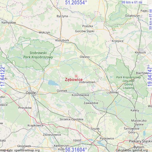
Zębowice GPS coordinates[2]
50° 45' 46.44" North, 18° 20' 39.624" East
| Map corner | latitude | longitude |
|---|---|---|
| Upper-left | 51.20554°, | 17.64122° |
| Center: | 50.7629°, | 18.34434° |
| Lower-right: | 50.31604°, | 19.04747° |
| Map W x H: | 98.9×98.9 km | = 61.5×61.5mi |
| max Lat: | 54.83135° ⇑61.1% North |
| Zębowice: | 50.7629° |
| min Lat: | ⇓38.9% South 49.21328° |
| min Long | Zębowice | max Long |
| 14.20249° | 18.34434° | 24.03723° |
| W 29.4%⇐ | ⇒70.6% E |
Elevation
Elevation of Zębowice is 219 m = 719 ft, and this is 27.6 m = 91 ft above average elevation for this country.
| Max E: |
974 m = 3196 ft | 33.3% |
| Zębowice | 219 m 719 ft | |
| Avg. | 191.4 m = 628 ft | |
Min E: |
-3 m = -10 ft | 66.7% |
See also: Poland elevation on elevation.city.
Geographical zone
Zębowice is located in North temperate zone (between Tropic of Cancer and the Arctic Circle). Distance of this North polar circle is 1756.9 km =1091.7 mi to North.| Distance of | km | miles | from Zębowice |
|---|---|---|---|
| North Pole | 4362.8 | 2710.9 | to North |
| Arctic Circle | 1756.9 | 1091.7 | to North |
| Tropic Cancer | 3038.4 | 1888 | to South |
| Equator | 5644.3 | 3507.2 | to South |


Nearby cities:
15 places around Zębowice: (largest is in red/bold)
• Bierdzany
14.5 km =9 mi,  295°
295°
• Ciasna
18.6 km =11.6 mi,  92°
92°
• Dobrodzień
8 km =5 mi,  118°
118°
• Gwoździany
13.8 km =8.6 mi,  109°
109°
• Kolonowskie
12.5 km =7.8 mi,  166°
166°
• Lasowice Małe
16.9 km =10.5 mi,  338°
338°
• Lasowice Wielkie
14.5 km =9 mi,  325°
325°
• Olesno
13.8 km =8.6 mi,  22°
22°
• Ozimek
13.1 km =8.1 mi,  224°
224°
• Pawonków
18.3 km =11.4 mi, 114°
• Sieraków Śląski
16.8 km =10.4 mi,  74°
74°
• Turawa
19 km =11.8 mi,  262°
262°
• Wojciechów
15.3 km =9.5 mi,  12°
12°
• Zawadzkie
20.1 km =12.5 mi,  150°
150°
• Łaziska
19.7 km =12.2 mi,  175°
175°
Sources, notices
• [Note1] Compared only with cities in Poland existing in our database
• [Src1] Map data: © OpenStreetMap contributors (CC-BY-SA)
• [Src2] Other city data from geonames.org with taken over terms of usage.
• [Src3] Geographical zone / Annual Mean Temperature by Robert A. Rohde @ Wikipedia
