Kobiór geodata
Kobiór (Silesia) is a seat of a third-order administrative division; located in Poland in Europe/Warsaw (GMT+2) time zone. With population of 4,702 people, there are 713 cities with bigger population in this country. Compared to other cities in Poland, 79.6% of cities are located further ↑North; 61.2% of cities are located further →East and 75.5% of cities have lower elevation than Kobiór. Note1


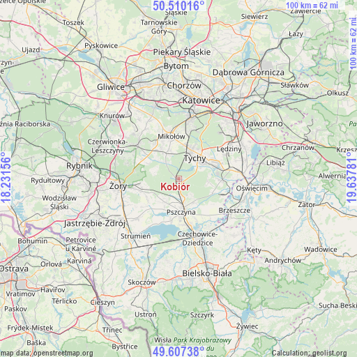
Kobiór GPS coordinates[2]
50° 3' 39.204" North, 18° 56' 4.848" East
| Map corner | latitude | longitude |
|---|---|---|
| Upper-left | 50.51016°, | 18.23156° |
| Center: | 50.06089°, | 18.93468° |
| Lower-right: | 49.60738°, | 19.63781° |
| Map W x H: | 100.4×100.4 km | = 62.4×62.4mi |
| max Lat: | 54.83135° ⇑79.6% North |
| Kobiór: | 50.06089° |
| min Lat: | ⇓20.4% South 49.21328° |
| min Long | Kobiór | max Long |
| 14.20249° | 18.93468° | 24.03723° |
| W 38.8%⇐ | ⇒61.2% E |
Elevation
Elevation of Kobiór is 248 m = 814 ft, and this is 56.6 m = 186 ft above average elevation for this country.
| Max E: |
974 m = 3196 ft | 24.5% |
| Kobiór | 248 m 814 ft | |
| Avg. | 191.4 m = 628 ft | |
Min E: |
-3 m = -10 ft | 75.5% |
See also: Poland elevation on elevation.city.
Geographical zone
Kobiór is located in North temperate zone (between Tropic of Cancer and the Arctic Circle). Distance of this North polar circle is 1834.9 km =1140.2 mi to North.| Distance of | km | miles | from Kobiór |
|---|---|---|---|
| North Pole | 4440.8 | 2759.4 | to North |
| Arctic Circle | 1834.9 | 1140.2 | to North |
| Tropic Cancer | 2960.3 | 1839.4 | to South |
| Equator | 5566.2 | 3458.7 | to South |


Nearby cities:
15 places around Kobiór: (largest is in red/bold)
• Bieruń
11.7 km =7.3 mi,  74°
74°
• Bojszowy Nowe
8.3 km =5.2 mi,  96°
96°
• Cielmice
6.7 km =4.2 mi,  63°
63°
• Czarków
5.1 km =3.2 mi,  202°
202°
• Gardawice
11.4 km =7.1 mi,  302°
302°
• Gostyń
6.2 km =3.9 mi,  322°
322°
• Jankowice
7.7 km =4.8 mi,  149°
149°
• Kryry
10.4 km =6.5 mi,  241°
241°
• Międzyrzecze
10.1 km =6.3 mi,  113°
113°
• Piasek
5.7 km =3.5 mi,  170°
170°
• Pszczyna
9.1 km =5.7 mi, 171°
• Radostowice
7.5 km =4.7 mi,  210°
210°
• Suszec
10.8 km =6.7 mi,  251°
251°
• Tychy
8.8 km =5.5 mi,  14°
14°
• Wyry
8.4 km =5.2 mi,  343°
343°
Sources, notices
• [Note1] Compared only with cities in Poland existing in our database
• [Src1] Map data: © OpenStreetMap contributors (CC-BY-SA)
• [Src2] Other city data from geonames.org with taken over terms of usage.
• [Src3] Geographical zone / Annual Mean Temperature by Robert A. Rohde @ Wikipedia
