Wyry geodata
Wyry (Silesia) is a seat of a third-order administrative division; located in Poland in Europe/Warsaw (GMT+2) time zone. With population of 3,304 people, there are 964 cities with bigger population in this country. Compared to other cities in Poland, 76.7% of cities are located further ↑North; 62% of cities are located further →East and 83.4% of cities have lower elevation than Wyry. Note1


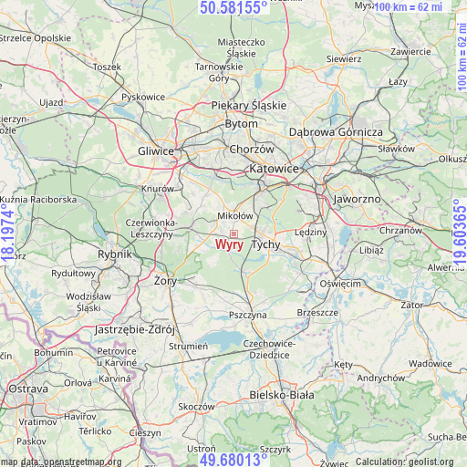
Wyry GPS coordinates[2]
50° 7' 58.656" North, 18° 54' 1.872" East
| Map corner | latitude | longitude |
|---|---|---|
| Upper-left | 50.58155°, | 18.1974° |
| Center: | 50.13296°, | 18.90052° |
| Lower-right: | 49.68013°, | 19.60365° |
| Map W x H: | 100.2×100.2 km | = 62.3×62.3mi |
| max Lat: | 54.83135° ⇑76.7% North |
| Wyry: | 50.13296° |
| min Lat: | ⇓23.3% South 49.21328° |
| min Long | Wyry | max Long |
| 14.20249° | 18.90052° | 24.03723° |
| W 38%⇐ | ⇒62% E |
Elevation
Elevation of Wyry is 282 m = 925 ft, and this is 90.6 m = 297 ft above average elevation for this country.
| Max E: |
974 m = 3196 ft | 16.6% |
| Wyry | 282 m 925 ft | |
| Avg. | 191.4 m = 628 ft | |
Min E: |
-3 m = -10 ft | 83.4% |
See also: Poland elevation on elevation.city.
Geographical zone
Wyry is located in North temperate zone (between Tropic of Cancer and the Arctic Circle). Distance of this North polar circle is 1826.9 km =1135.2 mi to North.| Distance of | km | miles | from Wyry |
|---|---|---|---|
| North Pole | 4432.8 | 2754.4 | to North |
| Arctic Circle | 1826.9 | 1135.2 | to North |
| Tropic Cancer | 2968.3 | 1844.4 | to South |
| Equator | 5574.3 | 3463.7 | to South |


Nearby cities:
15 places around Wyry: (largest is in red/bold)
• Bełk
13.1 km =8.1 mi,  268°
268°
• Bojszowy Nowe
13.9 km =8.6 mi,  129°
129°
• Cielmice
9.8 km =6.1 mi,  120°
120°
• Czarków
12.8 km =8 mi,  177°
177°
• Gardawice
7.4 km =4.6 mi,  255°
255°
• Gostyń
3.3 km =2.1 mi,  202°
202°
• Kobiór
8.4 km =5.2 mi,  163°
163°
• Mikołów
4.2 km =2.6 mi,  3°
3°
• Murcki
12.6 km =7.8 mi,  53°
53°
• Ornontowice
12.4 km =7.7 mi,  303°
303°
• Orzesze
9 km =5.6 mi,  286°
286°
• Paniówki
13.9 km =8.6 mi,  322°
322°
• Suszec
13.9 km =8.6 mi,  214°
214°
• Tychy
4.7 km =2.9 mi,  84°
84°
• Łaziska Górne
4.5 km =2.8 mi, 293°
Sources, notices
• [Note1] Compared only with cities in Poland existing in our database
• [Src1] Map data: © OpenStreetMap contributors (CC-BY-SA)
• [Src2] Other city data from geonames.org with taken over terms of usage.
• [Src3] Geographical zone / Annual Mean Temperature by Robert A. Rohde @ Wikipedia
