Marzęcino geodata
Marzęcino (Pomerania) is a populated place; located in Poland in Europe/Warsaw (GMT+2) time zone. With population of 700 people, there are 3061 cities with bigger population in this country. Compared to other cities in Poland, 96.8% of cities are located further ↓South; 55.4% of cities are located further →East and 99.8% of cities have higher elevation than Marzęcino. Note1
Administrative division(s):
- Level 1: Pomerania
- Level 2: Powiat nowodworski
- Level 3: Nowy Dwór Gdański


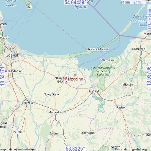
Marzęcino GPS coordinates[2]
54° 14' 7.764" North, 19° 14' 5.388" East
| Map corner | latitude | longitude |
|---|---|---|
| Upper-left | 54.64439°, | 18.53171° |
| Center: | 54.23549°, | 19.23483° |
| Lower-right: | 53.8225°, | 19.93796° |
| Map W x H: | 91.4×91.4 km | = 56.8×56.8mi |
| max Lat: | 54.83135° ⇑3.2% North |
| Marzęcino: | 54.23549° |
| min Lat: | ⇓96.8% South 49.21328° |
| min Long | Marzęcino | max Long |
| 14.20249° | 19.23483° | 24.03723° |
| W 44.6%⇐ | ⇒55.4% E |
Elevation
Elevation of Marzęcino is 1 m = 3 ft, and this is 190.4 m = 625 ft below average elevation for this country.
| Max E: |
974 m = 3196 ft | 99.8% |
| Avg. | 191.4 m = 628 ft | |
| Marzęcino | 1 m = 3 ft | |
Min E: |
-3 m = -10 ft | 0.2% |
See also: Poland elevation on elevation.city.
Geographical zone
Marzęcino is located in North temperate zone (between Tropic of Cancer and the Arctic Circle). Distance of this North polar circle is 1370.8 km =851.8 mi to North.| Distance of | km | miles | from Marzęcino |
|---|---|---|---|
| North Pole | 3976.6 | 2470.9 | to North |
| Arctic Circle | 1370.8 | 851.8 | to North |
| Tropic Cancer | 3424.5 | 2127.9 | to South |
| Equator | 6030.4 | 3747.1 | to South |


Nearby cities:
15 places around Marzęcino: (largest is in red/bold)
• Drewnica
19 km =11.8 mi,  287°
287°
• Elbląg
14.6 km =9.1 mi,  129°
129°
• Gronowo Elbląskie
17.3 km =10.7 mi,  164°
164°
• Gronowo Górne
18.2 km =11.3 mi, 126°
• Jantar
17.2 km =10.7 mi,  310°
310°
• Kmiecin
7.6 km =4.7 mi,  227°
227°
• Kąty Rybackie
11.6 km =7.2 mi,  358°
358°
• Lubieszewo
13.8 km =8.6 mi,  248°
248°
• Nowy Dwór Gdański
8 km =5 mi, 251°
• Nowy Staw
18.4 km =11.4 mi, 233°
• Ostaszewo
18.6 km =11.6 mi,  262°
262°
• Stare Pole
20 km =12.4 mi,  184°
184°
• Stegna
12.9 km =8 mi,  321°
321°
• Suchacz
14.8 km =9.2 mi,  67°
67°
• Sztutowo
10.8 km =6.7 mi,  340°
340°
Sources, notices
• [Note1] Compared only with cities in Poland existing in our database
• [Src1] Map data: © OpenStreetMap contributors (CC-BY-SA)
• [Src2] Other city data from geonames.org with taken over terms of usage.
• [Src3] Geographical zone / Annual Mean Temperature by Robert A. Rohde @ Wikipedia
