Kmiecin geodata
Kmiecin (Pomerania) is a populated place; located in Poland in Europe/Warsaw (GMT+2) time zone. With population of 970 people, there are 2550 cities with bigger population in this country. Compared to other cities in Poland, 96.2% of cities are located further ↓South; 57.2% of cities are located further →East and 99.5% of cities have higher elevation than Kmiecin. Note1
Administrative division(s):
- Level 1: Pomerania
- Level 2: Powiat nowodworski
- Level 3: Nowy Dwór Gdański


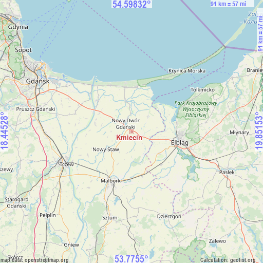
Kmiecin GPS coordinates[2]
54° 11' 20.256" North, 19° 8' 54.24" East
| Map corner | latitude | longitude |
|---|---|---|
| Upper-left | 54.59832°, | 18.44528° |
| Center: | 54.18896°, | 19.1484° |
| Lower-right: | 53.7755°, | 19.85153° |
| Map W x H: | 91.5×91.5 km | = 56.9×56.9mi |
| max Lat: | 54.83135° ⇑3.8% North |
| Kmiecin: | 54.18896° |
| min Lat: | ⇓96.2% South 49.21328° |
| min Long | Kmiecin | max Long |
| 14.20249° | 19.1484° | 24.03723° |
| W 42.8%⇐ | ⇒57.2% E |
Elevation
Elevation of Kmiecin is 2 m = 7 ft, and this is 189.4 m = 621 ft below average elevation for this country.
| Max E: |
974 m = 3196 ft | 99.5% |
| Avg. | 191.4 m = 628 ft | |
| Kmiecin | 2 m = 7 ft | |
Min E: |
-3 m = -10 ft | 0.5% |
See also: Poland elevation on elevation.city.
Geographical zone
Kmiecin is located in North temperate zone (between Tropic of Cancer and the Arctic Circle). Distance of this North polar circle is 1375.9 km =854.9 mi to North.| Distance of | km | miles | from Kmiecin |
|---|---|---|---|
| North Pole | 3981.8 | 2474.2 | to North |
| Arctic Circle | 1375.9 | 854.9 | to North |
| Tropic Cancer | 3419.3 | 2124.7 | to South |
| Equator | 6025.2 | 3743.9 | to South |


Nearby cities:
15 places around Kmiecin: (largest is in red/bold)
• Drewnica
16.6 km =10.3 mi,  311°
311°
• Elbląg
17.4 km =10.8 mi,  103°
103°
• Gronowo Elbląskie
15.4 km =9.6 mi,  138°
138°
• Jantar
18 km =11.2 mi,  335°
335°
• Kąty Rybackie
17.6 km =10.9 mi,  17°
17°
• Lichnowy
17.3 km =10.7 mi,  241°
241°
• Lubieszewo
7.2 km =4.5 mi,  270°
270°
• Malbork
18.8 km =11.7 mi,  205°
205°
• Marzęcino
7.6 km =4.7 mi,  47°
47°
• Nowy Dwór Gdański
3.3 km =2.1 mi,  323°
323°
• Nowy Staw
10.8 km =6.7 mi, 237°
• Ostaszewo
13.1 km =8.1 mi,  281°
281°
• Stare Pole
15.2 km =9.4 mi,  165°
165°
• Stegna
15.5 km =9.6 mi,  351°
351°
• Sztutowo
15.5 km =9.6 mi,  7°
7°
Sources, notices
• [Note1] Compared only with cities in Poland existing in our database
• [Src1] Map data: © OpenStreetMap contributors (CC-BY-SA)
• [Src2] Other city data from geonames.org with taken over terms of usage.
• [Src3] Geographical zone / Annual Mean Temperature by Robert A. Rohde @ Wikipedia
