Elbląg geodata
Elbląg (Warmia-Masuria) is a seat of a second-order administrative division; located in Poland in Europe/Warsaw (GMT+2) time zone. With population of 127,558 people, there are 34 cities with bigger population in this country. Compared to other cities in Poland, 95.8% of cities are located further ↓South; 52.5% of cities are located further →East and 98.4% of cities have higher elevation than Elbląg. Note1


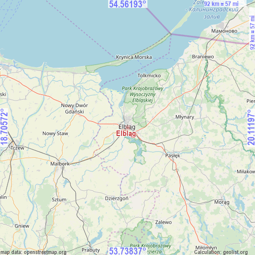
Elbląg GPS coordinates[2]
54° 9' 7.92" North, 19° 24' 31.824" East
| Map corner | latitude | longitude |
|---|---|---|
| Upper-left | 54.56193°, | 18.70572° |
| Center: | 54.1522°, | 19.40884° |
| Lower-right: | 53.73837°, | 20.11197° |
| Map W x H: | 91.6×91.6 km | = 56.9×56.9mi |
| max Lat: | 54.83135° ⇑4.2% North |
| Elbląg: | 54.1522° |
| min Lat: | ⇓95.8% South 49.21328° |
| min Long | Elbląg | max Long |
| 14.20249° | 19.40884° | 24.03723° |
| W 47.5%⇐ | ⇒52.5% E |
Elevation
Elevation of Elbląg is 8 m = 26 ft, and this is 183.4 m = 602 ft below average elevation for this country.
| Max E: |
974 m = 3196 ft | 98.4% |
| Avg. | 191.4 m = 628 ft | |
| Elbląg | 8 m = 26 ft | |
Min E: |
-3 m = -10 ft | 1.6% |
See also: Elbląg elevation on elevation.city.
Geographical zone
Elbląg is located in North temperate zone (between Tropic of Cancer and the Arctic Circle). Distance of this North polar circle is 1380 km =857.5 mi to North.| Distance of | km | miles | from Elbląg |
|---|---|---|---|
| North Pole | 3985.9 | 2476.7 | to North |
| Arctic Circle | 1380 | 857.5 | to North |
| Tropic Cancer | 3415.2 | 2122.1 | to South |
| Equator | 6021.2 | 3741.4 | to South |


Nearby cities:
15 places around Elbląg: (largest is in red/bold)
• Gronowo Elbląskie
10 km =6.2 mi,  222°
222°
• Gronowo Górne
3.7 km =2.3 mi,  114°
114°
• Kamiennik Wielki
9.6 km =6 mi,  67°
67°
• Kmiecin
17.4 km =10.8 mi,  283°
283°
• Kąty Rybackie
23.9 km =14.9 mi,  330°
330°
• Markusy
11.3 km =7 mi,  183°
183°
• Marzęcino
14.6 km =9.1 mi,  309°
309°
• Młynary
20.7 km =12.9 mi,  79°
79°
• Nowy Dwór Gdański
20.1 km =12.5 mi,  289°
289°
• Pasłęk
19.2 km =11.9 mi,  121°
121°
• Rychliki
20.1 km =12.5 mi,  157°
157°
• Stare Pole
16.8 km =10.4 mi,  230°
230°
• Suchacz
15.1 km =9.4 mi,  9°
9°
• Sztutowo
24.5 km =15.2 mi,  322°
322°
• Tolkmicko
20.2 km =12.6 mi,  22°
22°
Sources, notices
• [Note1] Compared only with cities in Poland existing in our database
• [Src1] Map data: © OpenStreetMap contributors (CC-BY-SA)
• [Src2] Other city data from geonames.org with taken over terms of usage.
• [Src3] Geographical zone / Annual Mean Temperature by Robert A. Rohde @ Wikipedia
