Jantar geodata
Jantar (Pomerania) is a populated place; located in Poland in Europe/Warsaw (GMT+2) time zone. With population of 940 people, there are 2606 cities with bigger population in this country. Compared to other cities in Poland, 97.9% of cities are located further ↓South; 59.5% of cities are located further →East and 99.3% of cities have higher elevation than Jantar. Note1


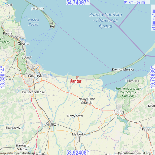
Jantar GPS coordinates[2]
54° 20' 9.852" North, 19° 1' 59.736" East
| Map corner | latitude | longitude |
|---|---|---|
| Upper-left | 54.74397°, | 18.33014° |
| Center: | 54.33607°, | 19.03326° |
| Lower-right: | 53.92408°, | 19.73639° |
| Map W x H: | 91.2×91.2 km | = 56.7×56.7mi |
| max Lat: | 54.83135° ⇑2.1% North |
| Jantar: | 54.33607° |
| min Lat: | ⇓97.9% South 49.21328° |
| min Long | Jantar | max Long |
| 14.20249° | 19.03326° | 24.03723° |
| W 40.5%⇐ | ⇒59.5% E |
Elevation
Elevation of Jantar is 3 m = 10 ft, and this is 188.4 m = 618 ft below average elevation for this country.
| Max E: |
974 m = 3196 ft | 99.3% |
| Avg. | 191.4 m = 628 ft | |
| Jantar | 3 m = 10 ft | |
Min E: |
-3 m = -10 ft | 0.7% |
See also: Poland elevation on elevation.city.
Geographical zone
Jantar is located in North temperate zone (between Tropic of Cancer and the Arctic Circle). Distance of this North polar circle is 1359.6 km =844.8 mi to North.| Distance of | km | miles | from Jantar |
|---|---|---|---|
| North Pole | 3965.5 | 2464 | to North |
| Arctic Circle | 1359.6 | 844.8 | to North |
| Tropic Cancer | 3435.7 | 2134.8 | to South |
| Equator | 6041.6 | 3754.1 | to South |


Nearby cities:
15 places around Jantar: (largest is in red/bold)
• Cedry Wielkie
15.7 km =9.8 mi,  230°
230°
• Drewnica
7.3 km =4.5 mi,  222°
222°
• Kmiecin
18 km =11.2 mi,  155°
155°
• Kąty Rybackie
12.7 km =7.9 mi,  88°
88°
• Lubieszewo
16.2 km =10.1 mi,  179°
179°
• Marzęcino
17.2 km =10.7 mi,  130°
130°
• Mikoszewo
4.3 km =2.7 mi,  266°
266°
• Nowy Dwór Gdański
14.7 km =9.1 mi, 158°
• Nowy Staw
22.3 km =13.9 mi, 184°
• Ostaszewo
14.7 km =9.1 mi,  201°
201°
• Przejazdowo
18.8 km =11.7 mi, 266°
• Stegna
5.2 km =3.2 mi,  101°
101°
• Suchy Dąb
22.4 km =13.9 mi, 230°
• Sztutowo
9.5 km =5.9 mi, 96°
• Wiślinka
15.4 km =9.6 mi, 269°
Sources, notices
• [Note1] Compared only with cities in Poland existing in our database
• [Src1] Map data: © OpenStreetMap contributors (CC-BY-SA)
• [Src2] Other city data from geonames.org with taken over terms of usage.
• [Src3] Geographical zone / Annual Mean Temperature by Robert A. Rohde @ Wikipedia
