Lubieszewo geodata
Lubieszewo (Pomerania) is a populated place; located in Poland in Europe/Warsaw (GMT+2) time zone. With population of 780 people, there are 2898 cities with bigger population in this country. Compared to other cities in Poland, 96.2% of cities are located further ↓South; 59.4% of cities are located further →East and 99.8% of cities have higher elevation than Lubieszewo. Note1
Administrative division(s):
- Level 1: Pomerania
- Level 2: Powiat nowodworski
- Level 3: Nowy Dwór Gdański


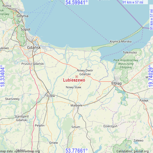
Lubieszewo GPS coordinates[2]
54° 11' 24.216" North, 19° 2' 13.776" East
| Map corner | latitude | longitude |
|---|---|---|
| Upper-left | 54.59941°, | 18.33404° |
| Center: | 54.19006°, | 19.03716° |
| Lower-right: | 53.77661°, | 19.74029° |
| Map W x H: | 91.5×91.5 km | = 56.9×56.9mi |
| max Lat: | 54.83135° ⇑3.8% North |
| Lubieszewo: | 54.19006° |
| min Lat: | ⇓96.2% South 49.21328° |
| min Long | Lubieszewo | max Long |
| 14.20249° | 19.03716° | 24.03723° |
| W 40.6%⇐ | ⇒59.4% E |
Elevation
Elevation of Lubieszewo is 1 m = 3 ft, and this is 190.4 m = 625 ft below average elevation for this country.
| Max E: |
974 m = 3196 ft | 99.8% |
| Avg. | 191.4 m = 628 ft | |
| Lubieszewo | 1 m = 3 ft | |
Min E: |
-3 m = -10 ft | 0.2% |
See also: Poland elevation on elevation.city.
Geographical zone
Lubieszewo is located in North temperate zone (between Tropic of Cancer and the Arctic Circle). Distance of this North polar circle is 1375.8 km =854.9 mi to North.| Distance of | km | miles | from Lubieszewo |
|---|---|---|---|
| North Pole | 3981.7 | 2474.1 | to North |
| Arctic Circle | 1375.8 | 854.9 | to North |
| Tropic Cancer | 3419.5 | 2124.8 | to South |
| Equator | 6025.4 | 3744 | to South |


Nearby cities:
15 places around Lubieszewo: (largest is in red/bold)
• Cedry Wielkie
14 km =8.7 mi,  296°
296°
• Drewnica
12 km =7.5 mi,  334°
334°
• Jantar
16.2 km =10.1 mi,  359°
359°
• Kmiecin
7.2 km =4.5 mi,  90°
90°
• Lichnowy
11.6 km =7.2 mi,  223°
223°
• Lisewo Malborskie
17.1 km =10.6 mi,  232°
232°
• Malbork
17.2 km =10.7 mi,  182°
182°
• Marzęcino
13.8 km =8.6 mi,  68°
68°
• Mikoszewo
16.6 km =10.3 mi,  344°
344°
• Nowy Dwór Gdański
5.8 km =3.6 mi,  63°
63°
• Nowy Staw
6.3 km =3.9 mi,  196°
196°
• Ostaszewo
6.1 km =3.8 mi,  294°
294°
• Stegna
16 km =9.9 mi,  17°
17°
• Suchy Dąb
17.7 km =11 mi,  276°
276°
• Sztutowo
17.8 km =11.1 mi,  31°
31°
Sources, notices
• [Note1] Compared only with cities in Poland existing in our database
• [Src1] Map data: © OpenStreetMap contributors (CC-BY-SA)
• [Src2] Other city data from geonames.org with taken over terms of usage.
• [Src3] Geographical zone / Annual Mean Temperature by Robert A. Rohde @ Wikipedia
