Lubichowo geodata
Lubichowo (Pomerania) is a populated place; located in Poland in Europe/Warsaw (GMT+2) time zone. With population of 2,276 people, there are 1332 cities with bigger population in this country. Compared to other cities in Poland, 92.9% of cities are located further ↓South; 69.7% of cities are located further →East and 78.4% of cities have higher elevation than Lubichowo. Note1


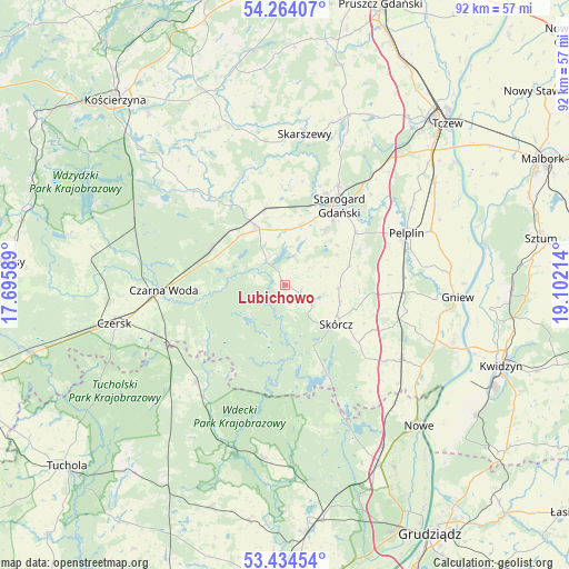
Lubichowo GPS coordinates[2]
53° 51' 4.896" North, 18° 23' 56.436" East
| Map corner | latitude | longitude |
|---|---|---|
| Upper-left | 54.26407°, | 17.69589° |
| Center: | 53.85136°, | 18.39901° |
| Lower-right: | 53.43454°, | 19.10214° |
| Map W x H: | 92.2×92.2 km | = 57.3×57.3mi |
| max Lat: | 54.83135° ⇑7.1% North |
| Lubichowo: | 53.85136° |
| min Lat: | ⇓92.9% South 49.21328° |
| min Long | Lubichowo | max Long |
| 14.20249° | 18.39901° | 24.03723° |
| W 30.3%⇐ | ⇒69.7% E |
Elevation
Elevation of Lubichowo is 103 m = 338 ft, and this is 88.4 m = 290 ft below average elevation for this country.
| Max E: |
974 m = 3196 ft | 78.4% |
| Avg. | 191.4 m = 628 ft | |
| Lubichowo | 103 m = 338 ft | |
Min E: |
-3 m = -10 ft | 21.6% |
See also: Poland elevation on elevation.city.
Geographical zone
Lubichowo is located in North temperate zone (between Tropic of Cancer and the Arctic Circle). Distance of this North polar circle is 1413.5 km =878.3 mi to North.| Distance of | km | miles | from Lubichowo |
|---|---|---|---|
| North Pole | 4019.4 | 2497.5 | to North |
| Arctic Circle | 1413.5 | 878.3 | to North |
| Tropic Cancer | 3381.8 | 2101.4 | to South |
| Equator | 5987.7 | 3720.6 | to South |


Nearby cities:
15 places around Lubichowo: (largest is in red/bold)
• Bobowo
11 km =6.8 mi,  70°
70°
• Czarna Woda
19.6 km =12.2 mi,  267°
267°
• Kaliska
13.2 km =8.2 mi,  296°
296°
• Kopytkowo
20.8 km =12.9 mi,  127°
127°
• Morzeszczyn
19.2 km =11.9 mi,  93°
93°
• Osieczna
15.6 km =9.7 mi,  235°
235°
• Osiek
15.6 km =9.7 mi,  157°
157°
• Pelplin
21.4 km =13.3 mi, 66°
• Skórcz
10.5 km =6.5 mi, 127°
• Smętowo Graniczne
22.2 km =13.8 mi,  121°
121°
• Stara Kiszewa
21.5 km =13.4 mi,  315°
315°
• Starogard Gdański
15 km =9.3 mi,  33°
33°
• Szlachta
20.9 km =13 mi, 243°
• Zblewo
10.4 km =6.5 mi,  331°
331°
• Śliwice
21.7 km =13.5 mi,  223°
223°
Sources, notices
• [Note1] Compared only with cities in Poland existing in our database
• [Src1] Map data: © OpenStreetMap contributors (CC-BY-SA)
• [Src2] Other city data from geonames.org with taken over terms of usage.
• [Src3] Geographical zone / Annual Mean Temperature by Robert A. Rohde @ Wikipedia
