Szlachta geodata
Szlachta (Pomerania) is a populated place; located in Poland in Europe/Warsaw (GMT+2) time zone. With population of 1,200 people, there are 2164 cities with bigger population in this country. Compared to other cities in Poland, 92% of cities are located further ↓South; 73.9% of cities are located further →East and 68.9% of cities have higher elevation than Szlachta. Note1


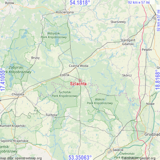
Szlachta GPS coordinates[2]
53° 46' 5.772" North, 18° 6' 49.212" East
| Map corner | latitude | longitude |
|---|---|---|
| Upper-left | 54.1818°, | 17.41055° |
| Center: | 53.76827°, | 18.11367° |
| Lower-right: | 53.35063°, | 18.8168° |
| Map W x H: | 92.4×92.4 km | = 57.4×57.4mi |
| max Lat: | 54.83135° ⇑8% North |
| Szlachta: | 53.76827° |
| min Lat: | ⇓92% South 49.21328° |
| min Long | Szlachta | max Long |
| 14.20249° | 18.11367° | 24.03723° |
| W 26.1%⇐ | ⇒73.9% E |
Elevation
Elevation of Szlachta is 123 m = 404 ft, and this is 68.4 m = 224 ft below average elevation for this country.
| Max E: |
974 m = 3196 ft | 68.9% |
| Avg. | 191.4 m = 628 ft | |
| Szlachta | 123 m = 404 ft | |
Min E: |
-3 m = -10 ft | 31.1% |
See also: Poland elevation on elevation.city.
Geographical zone
Szlachta is located in North temperate zone (between Tropic of Cancer and the Arctic Circle). Distance of this North polar circle is 1422.7 km =884 mi to North.| Distance of | km | miles | from Szlachta |
|---|---|---|---|
| North Pole | 4028.6 | 2503.3 | to North |
| Arctic Circle | 1422.7 | 884 | to North |
| Tropic Cancer | 3372.6 | 2095.6 | to South |
| Equator | 5978.5 | 3714.9 | to South |


Nearby cities:
15 places around Szlachta: (largest is in red/bold)
• Cekcyn
22.7 km =14.1 mi,  197°
197°
• Czarna Woda
8.5 km =5.3 mi,  353°
353°
• Czersk
9.5 km =5.9 mi,  288°
288°
• Kaliska
16.7 km =10.4 mi,  24°
24°
• Karsin
20 km =12.4 mi,  320°
320°
• Lubichowo
20.9 km =13 mi,  63°
63°
• Osie
24.1 km =15 mi,  141°
141°
• Osieczna
5.9 km =3.7 mi,  86°
86°
• Osiek
25.3 km =15.7 mi,  101°
101°
• Raciąż
24.5 km =15.2 mi,  241°
241°
• Skórcz
27.2 km =16.9 mi,  83°
83°
• Stara Kiszewa
24.9 km =15.5 mi,  8°
8°
• Tuchola
26.1 km =16.2 mi,  219°
219°
• Zblewo
22.9 km =14.2 mi,  36°
36°
• Śliwice
7.7 km =4.8 mi,  149°
149°
Sources, notices
• [Note1] Compared only with cities in Poland existing in our database
• [Src1] Map data: © OpenStreetMap contributors (CC-BY-SA)
• [Src2] Other city data from geonames.org with taken over terms of usage.
• [Src3] Geographical zone / Annual Mean Temperature by Robert A. Rohde @ Wikipedia
