Stara Kiszewa geodata
Stara Kiszewa (Pomerania) is a populated place; located in Poland in Europe/Warsaw (GMT+2) time zone. With population of 1,480 people, there are 1891 cities with bigger population in this country. Compared to other cities in Poland, 94.1% of cities are located further ↓South; 73.1% of cities are located further →East and 69.3% of cities have higher elevation than Stara Kiszewa. Note1


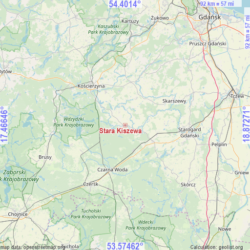
Stara Kiszewa GPS coordinates[2]
53° 59' 24.216" North, 18° 10' 10.488" East
| Map corner | latitude | longitude |
|---|---|---|
| Upper-left | 54.4014°, | 17.46646° |
| Center: | 53.99006°, | 18.16958° |
| Lower-right: | 53.57462°, | 18.87271° |
| Map W x H: | 91.9×91.9 km | = 57.1×57.1mi |
| max Lat: | 54.83135° ⇑5.9% North |
| Stara Kiszewa: | 53.99006° |
| min Lat: | ⇓94.1% South 49.21328° |
| min Long | Stara Kiszewa | max Long |
| 14.20249° | 18.16958° | 24.03723° |
| W 26.9%⇐ | ⇒73.1% E |
Elevation
Elevation of Stara Kiszewa is 122 m = 400 ft, and this is 69.4 m = 228 ft below average elevation for this country.
| Max E: |
974 m = 3196 ft | 69.3% |
| Avg. | 191.4 m = 628 ft | |
| Stara Kiszewa | 122 m = 400 ft | |
Min E: |
-3 m = -10 ft | 30.7% |
See also: Poland elevation on elevation.city.
Geographical zone
Stara Kiszewa is located in North temperate zone (between Tropic of Cancer and the Arctic Circle). Distance of this North polar circle is 1398 km =868.7 mi to North.| Distance of | km | miles | from Stara Kiszewa |
|---|---|---|---|
| North Pole | 4003.9 | 2487.9 | to North |
| Arctic Circle | 1398 | 868.7 | to North |
| Tropic Cancer | 3397.2 | 2110.9 | to South |
| Equator | 6003.1 | 3730.2 | to South |


Nearby cities:
15 places around Stara Kiszewa: (largest is in red/bold)
• Czarna Woda
16.8 km =10.4 mi,  195°
195°
• Czersk
25 km =15.5 mi,  210°
210°
• Grabowo Kościerskie
19.9 km =12.4 mi,  355°
355°
• Kaliska
10 km =6.2 mi,  161°
161°
• Karsin
18.7 km =11.6 mi,  240°
240°
• Kościerzyna
19.2 km =11.9 mi,  320°
320°
• Liniewo
10.3 km =6.4 mi,  21°
21°
• Lubichowo
21.5 km =13.4 mi,  135°
135°
• Nowa Karczma
16.1 km =10 mi,  7°
7°
• Osieczna
24.4 km =15.2 mi,  174°
174°
• Przywidz
24.9 km =15.5 mi, 23°
• Skarszewy
20 km =12.4 mi,  63°
63°
• Starogard Gdański
23.5 km =14.6 mi,  97°
97°
• Szlachta
24.9 km =15.5 mi,  188°
188°
• Zblewo
11.8 km =7.3 mi,  122°
122°
Sources, notices
• [Note1] Compared only with cities in Poland existing in our database
• [Src1] Map data: © OpenStreetMap contributors (CC-BY-SA)
• [Src2] Other city data from geonames.org with taken over terms of usage.
• [Src3] Geographical zone / Annual Mean Temperature by Robert A. Rohde @ Wikipedia
