Bobowo geodata
Bobowo (Pomerania) is a populated place; located in Poland in Europe/Warsaw (GMT+2) time zone. With population of 1,271 people, there are 2109 cities with bigger population in this country. Compared to other cities in Poland, 93% of cities are located further ↓South; 67.3% of cities are located further →East and 91.8% of cities have higher elevation than Bobowo. Note1


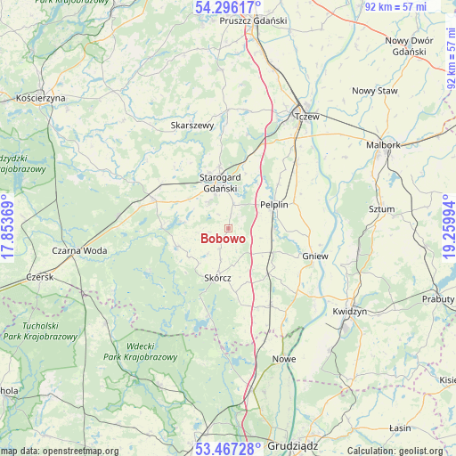
Bobowo GPS coordinates[2]
53° 53' 1.608" North, 18° 33' 24.516" East
| Map corner | latitude | longitude |
|---|---|---|
| Upper-left | 54.29617°, | 17.85369° |
| Center: | 53.88378°, | 18.55681° |
| Lower-right: | 53.46728°, | 19.25994° |
| Map W x H: | 92.2×92.2 km | = 57.3×57.3mi |
| max Lat: | 54.83135° ⇑7% North |
| Bobowo: | 53.88378° |
| min Lat: | ⇓93% South 49.21328° |
| min Long | Bobowo | max Long |
| 14.20249° | 18.55681° | 24.03723° |
| W 32.7%⇐ | ⇒67.3% E |
Elevation
Elevation of Bobowo is 66 m = 217 ft, and this is 125.4 m = 411 ft below average elevation for this country.
| Max E: |
974 m = 3196 ft | 91.8% |
| Avg. | 191.4 m = 628 ft | |
| Bobowo | 66 m = 217 ft | |
Min E: |
-3 m = -10 ft | 8.2% |
See also: Poland elevation on elevation.city.
Geographical zone
Bobowo is located in North temperate zone (between Tropic of Cancer and the Arctic Circle). Distance of this North polar circle is 1409.9 km =876.1 mi to North.| Distance of | km | miles | from Bobowo |
|---|---|---|---|
| North Pole | 4015.7 | 2495.2 | to North |
| Arctic Circle | 1409.9 | 876.1 | to North |
| Tropic Cancer | 3385.4 | 2103.6 | to South |
| Equator | 5991.3 | 3722.8 | to South |


Nearby cities:
15 places around Bobowo: (largest is in red/bold)
• Gniew
18.3 km =11.4 mi,  106°
106°
• Kaliska
22.3 km =13.9 mi,  276°
276°
• Kopytkowo
17.4 km =10.8 mi,  159°
159°
• Lubichowo
11 km =6.8 mi,  250°
250°
• Morzeszczyn
10.1 km =6.3 mi,  118°
118°
• Osiek
18.5 km =11.5 mi,  193°
193°
• Pelplin
10.5 km =6.5 mi,  61°
61°
• Skarszewy
21.9 km =13.6 mi,  340°
340°
• Skórcz
10.2 km =6.3 mi, 191°
• Smętowo Graniczne
17.5 km =10.9 mi,  150°
150°
• Starogard Gdański
9.1 km =5.7 mi,  347°
347°
• Subkowy
19.2 km =11.9 mi,  46°
46°
• Wielkie Walichnowy
19.7 km =12.2 mi,  79°
79°
• Zblewo
16.3 km =10.1 mi,  289°
289°
• Zduny
15 km =9.3 mi,  17°
17°
Sources, notices
• [Note1] Compared only with cities in Poland existing in our database
• [Src1] Map data: © OpenStreetMap contributors (CC-BY-SA)
• [Src2] Other city data from geonames.org with taken over terms of usage.
• [Src3] Geographical zone / Annual Mean Temperature by Robert A. Rohde @ Wikipedia
