Lipinki Łużyckie geodata
Lipinki Łużyckie (Lubusz) is a seat of a third-order administrative division; located in Poland in Europe/Warsaw (GMT+2) time zone. With population of 1,800 people, there are 1605 cities with bigger population in this country. Compared to other cities in Poland, 58.8% of cities are located further ↓South; 98.1% of cities are located further →East and 60.6% of cities have higher elevation than Lipinki Łużyckie. Note1


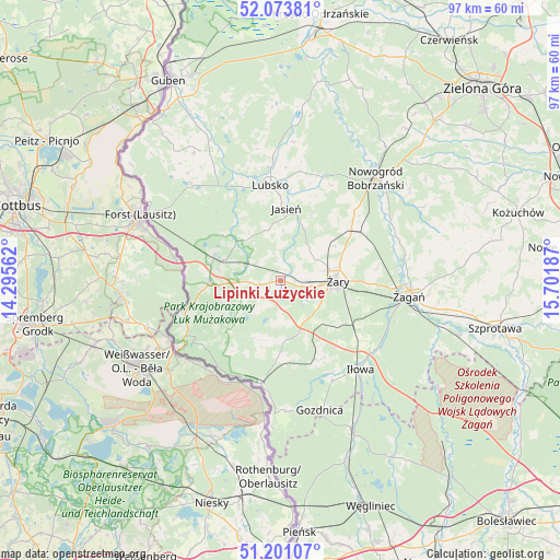
Lipinki Łużyckie GPS coordinates[2]
51° 38' 22.344" North, 14° 59' 55.464" East
| Map corner | latitude | longitude |
|---|---|---|
| Upper-left | 52.07381°, | 14.29562° |
| Center: | 51.63954°, | 14.99874° |
| Lower-right: | 51.20107°, | 15.70187° |
| Map W x H: | 97×97 km | = 60.3×60.3mi |
| max Lat: | 54.83135° ⇑41.2% North |
| Lipinki Łużyckie: | 51.63954° |
| min Lat: | ⇓58.8% South 49.21328° |
| min Long | Lipinki Łużyc | max Long |
| 14.20249° | 14.99874° | 24.03723° |
| W 1.9%⇐ | ⇒98.1% E |
Elevation
Elevation of Lipinki Łużyckie is 145 m = 476 ft, and this is 46.4 m = 152 ft below average elevation for this country.
| Max E: |
974 m = 3196 ft | 60.6% |
| Avg. | 191.4 m = 628 ft | |
| Lipinki Łużyckie | 145 m = 476 ft | |
Min E: |
-3 m = -10 ft | 39.4% |
See also: Poland elevation on elevation.city.
Geographical zone
Lipinki Łużyckie is located in North temperate zone (between Tropic of Cancer and the Arctic Circle). Distance of this North polar circle is 1659.4 km =1031.1 mi to North.| Distance of | km | miles | from Lipinki Łużyckie |
|---|---|---|---|
| North Pole | 4265.3 | 2650.3 | to North |
| Arctic Circle | 1659.4 | 1031.1 | to North |
| Tropic Cancer | 3135.9 | 1948.6 | to South |
| Equator | 5741.8 | 3567.8 | to South |


Nearby cities:
15 places around Lipinki Łużyckie: (largest is in red/bold)
• Brody
22.9 km =14.2 mi,  317°
317°
• Gozdnica
23.6 km =14.7 mi,  163°
163°
• Iłowa
20.8 km =12.9 mi,  138°
138°
• Jasień
12.5 km =7.8 mi,  4°
4°
• Kunice Żarskie
12.3 km =7.6 mi,  111°
111°
• Lubsko
16.2 km =10.1 mi,  353°
353°
• Przewóz
18 km =11.2 mi,  190°
190°
• Sieniawa Żarska
4.3 km =2.7 mi,  89°
89°
• Trzebiel
12.6 km =7.8 mi,  267°
267°
• Tuplice
12.4 km =7.7 mi,  289°
289°
• Wymiarki
15.4 km =9.6 mi, 158°
• Łęknica
21.2 km =13.2 mi,  239°
239°
• Żagań
22 km =13.7 mi,  96°
96°
• Żarki Wielkie
17.2 km =10.7 mi,  252°
252°
• Żary
9.6 km =6 mi, 88°
Sources, notices
• [Note1] Compared only with cities in Poland existing in our database
• [Src1] Map data: © OpenStreetMap contributors (CC-BY-SA)
• [Src2] Other city data from geonames.org with taken over terms of usage.
• [Src3] Geographical zone / Annual Mean Temperature by Robert A. Rohde @ Wikipedia
