Wymiarki geodata
Wymiarki (Lubusz) is a populated place; located in Poland in Europe/Warsaw (GMT+2) time zone. With population of 1,300 people, there are 2055 cities with bigger population in this country. Compared to other cities in Poland, 56.5% of cities are located further ↓South; 97.4% of cities are located further →East and 61.1% of cities have higher elevation than Wymiarki. Note1


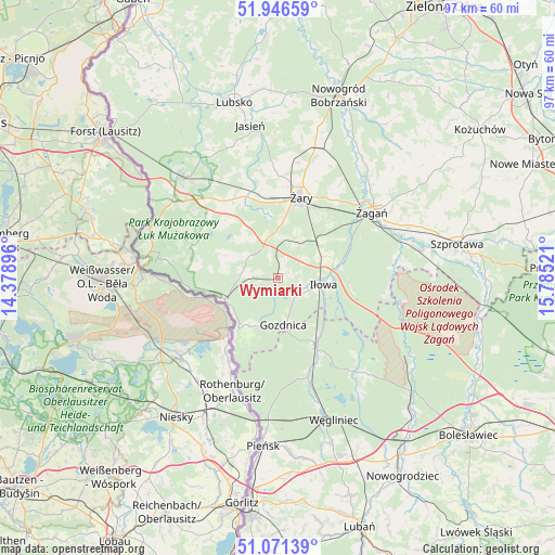
Wymiarki GPS coordinates[2]
51° 30' 39.924" North, 15° 4' 55.488" East
| Map corner | latitude | longitude |
|---|---|---|
| Upper-left | 51.94659°, | 14.37896° |
| Center: | 51.51109°, | 15.08208° |
| Lower-right: | 51.07139°, | 15.78521° |
| Map W x H: | 97.3×97.3 km | = 60.5×60.5mi |
| max Lat: | 54.83135° ⇑43.5% North |
| Wymiarki: | 51.51109° |
| min Lat: | ⇓56.5% South 49.21328° |
| min Long | Wymiarki | max Long |
| 14.20249° | 15.08208° | 24.03723° |
| W 2.6%⇐ | ⇒97.4% E |
Elevation
Elevation of Wymiarki is 144 m = 472 ft, and this is 47.4 m = 156 ft below average elevation for this country.
| Max E: |
974 m = 3196 ft | 61.1% |
| Avg. | 191.4 m = 628 ft | |
| Wymiarki | 144 m = 472 ft | |
Min E: |
-3 m = -10 ft | 38.9% |
See also: Poland elevation on elevation.city.
Geographical zone
Wymiarki is located in North temperate zone (between Tropic of Cancer and the Arctic Circle). Distance of this North polar circle is 1673.7 km =1040 mi to North.| Distance of | km | miles | from Wymiarki |
|---|---|---|---|
| North Pole | 4279.6 | 2659.2 | to North |
| Arctic Circle | 1673.7 | 1040 | to North |
| Tropic Cancer | 3121.6 | 1939.7 | to South |
| Equator | 5727.5 | 3558.9 | to South |


Nearby cities:
15 places around Wymiarki: (largest is in red/bold)
• Gozdnica
8.4 km =5.2 mi,  172°
172°
• Iłowa
8.2 km =5.1 mi,  98°
98°
• Jasień
27.1 km =16.8 mi,  350°
350°
• Kunice Żarskie
11.4 km =7.1 mi,  30°
30°
• Lipinki Łużyckie
15.4 km =9.6 mi,  338°
338°
• Małomice
25.9 km =16.1 mi,  78°
78°
• Przewóz
9.6 km =6 mi,  249°
249°
• Sieniawa Żarska
14.4 km =8.9 mi, 354°
• Trzebiel
23 km =14.3 mi,  306°
306°
• Tuplice
25.4 km =15.8 mi,  316°
316°
• Węgliniec
26.9 km =16.7 mi,  157°
157°
• Łęknica
24.2 km =15 mi,  278°
278°
• Żagań
20 km =12.4 mi,  53°
53°
• Żarki Wielkie
24.1 km =15 mi,  292°
292°
• Żary
15.1 km =9.4 mi,  14°
14°
Sources, notices
• [Note1] Compared only with cities in Poland existing in our database
• [Src1] Map data: © OpenStreetMap contributors (CC-BY-SA)
• [Src2] Other city data from geonames.org with taken over terms of usage.
• [Src3] Geographical zone / Annual Mean Temperature by Robert A. Rohde @ Wikipedia
