Przewóz geodata
Przewóz (Lubusz) is a seat of a third-order administrative division; located in Poland in Europe/Warsaw (GMT+2) time zone. With population of 850 people, there are 2772 cities with bigger population in this country. Compared to other cities in Poland, 56% of cities are located further ↓South; 98.3% of cities are located further →East and 62.7% of cities have higher elevation than Przewóz. Note1


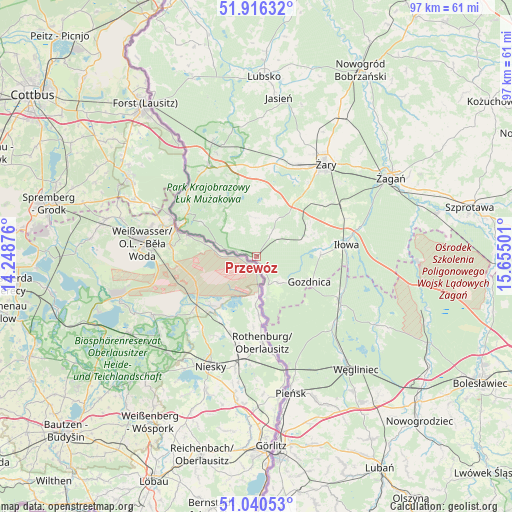
Przewóz GPS coordinates[2]
51° 28' 49.908" North, 14° 57' 6.768" East
| Map corner | latitude | longitude |
|---|---|---|
| Upper-left | 51.91632°, | 14.24876° |
| Center: | 51.48053°, | 14.95188° |
| Lower-right: | 51.04053°, | 15.65501° |
| Map W x H: | 97.4×97.4 km | = 60.5×60.5mi |
| max Lat: | 54.83135° ⇑44% North |
| Przewóz: | 51.48053° |
| min Lat: | ⇓56% South 49.21328° |
| min Long | Przewóz | max Long |
| 14.20249° | 14.95188° | 24.03723° |
| W 1.7%⇐ | ⇒98.3% E |
Elevation
Elevation of Przewóz is 140 m = 459 ft, and this is 51.4 m = 169 ft below average elevation for this country.
| Max E: |
974 m = 3196 ft | 62.7% |
| Avg. | 191.4 m = 628 ft | |
| Przewóz | 140 m = 459 ft | |
Min E: |
-3 m = -10 ft | 37.3% |
See also: Poland elevation on elevation.city.
Geographical zone
Przewóz is located in North temperate zone (between Tropic of Cancer and the Arctic Circle). Distance of this North polar circle is 1677.1 km =1042.1 mi to North.| Distance of | km | miles | from Przewóz |
|---|---|---|---|
| North Pole | 4283 | 2661.3 | to North |
| Arctic Circle | 1677.1 | 1042.1 | to North |
| Tropic Cancer | 3118.2 | 1937.6 | to South |
| Equator | 5724.1 | 3556.8 | to South |


Nearby cities:
15 places around Przewóz: (largest is in red/bold)
• Gozdnica
11.3 km =7 mi,  115°
115°
• Iłowa
17.3 km =10.7 mi,  82°
82°
• Jasień
30.4 km =18.9 mi,  8°
8°
• Kunice Żarskie
19.8 km =12.3 mi,  48°
48°
• Lipinki Łużyckie
18 km =11.2 mi, 10°
• Pieńsk
26.6 km =16.5 mi,  165°
165°
• Sieniawa Żarska
19.3 km =12 mi,  22°
22°
• Trzebiel
19.6 km =12.2 mi,  331°
331°
• Tuplice
23.4 km =14.5 mi,  338°
338°
• Wymiarki
9.6 km =6 mi,  69°
69°
• Węgliniec
28.8 km =17.9 mi,  138°
138°
• Łęknica
16.4 km =10.2 mi,  294°
294°
• Żagań
29.4 km =18.3 mi,  58°
58°
• Żarki Wielkie
18.3 km =11.4 mi,  313°
313°
• Żary
22.1 km =13.7 mi,  35°
35°
Sources, notices
• [Note1] Compared only with cities in Poland existing in our database
• [Src1] Map data: © OpenStreetMap contributors (CC-BY-SA)
• [Src2] Other city data from geonames.org with taken over terms of usage.
• [Src3] Geographical zone / Annual Mean Temperature by Robert A. Rohde @ Wikipedia
