Jasień geodata
Jasień (Lubusz) is a seat of a third-order administrative division; located in Poland in Europe/Warsaw (GMT+2) time zone. With population of 4,398 people, there are 751 cities with bigger population in this country. Compared to other cities in Poland, 61.1% of cities are located further ↓South; 98% of cities are located further →East and 86.8% of cities have higher elevation than Jasień. Note1


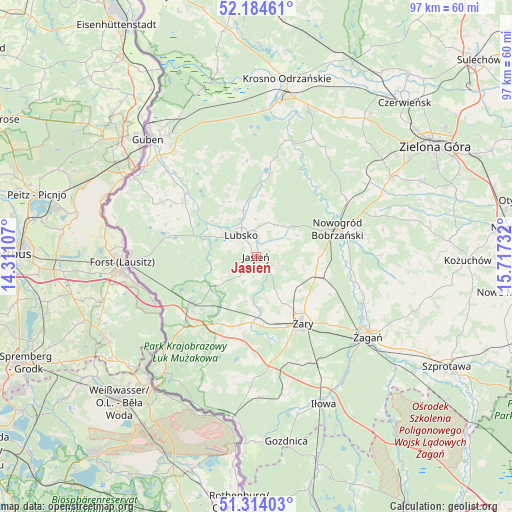
Jasień GPS coordinates[2]
51° 45' 5.112" North, 15° 0' 51.084" East
| Map corner | latitude | longitude |
|---|---|---|
| Upper-left | 52.18461°, | 14.31107° |
| Center: | 51.75142°, | 15.01419° |
| Lower-right: | 51.31403°, | 15.71732° |
| Map W x H: | 96.8×96.8 km | = 60.1×60.1mi |
| max Lat: | 54.83135° ⇑38.9% North |
| Jasień: | 51.75142° |
| min Lat: | ⇓61.1% South 49.21328° |
| min Long | Jasień | max Long |
| 14.20249° | 15.01419° | 24.03723° |
| W 2%⇐ | ⇒98% E |
Elevation
Elevation of Jasień is 85 m = 279 ft, and this is 106.4 m = 349 ft below average elevation for this country.
| Max E: |
974 m = 3196 ft | 86.8% |
| Avg. | 191.4 m = 628 ft | |
| Jasień | 85 m = 279 ft | |
Min E: |
-3 m = -10 ft | 13.2% |
See also: Poland elevation on elevation.city.
Geographical zone
Jasień is located in North temperate zone (between Tropic of Cancer and the Arctic Circle). Distance of this North polar circle is 1647 km =1023.4 mi to North.| Distance of | km | miles | from Jasień |
|---|---|---|---|
| North Pole | 4252.8 | 2642.6 | to North |
| Arctic Circle | 1647 | 1023.4 | to North |
| Tropic Cancer | 3148.3 | 1956.3 | to South |
| Equator | 5754.2 | 3575.5 | to South |


Nearby cities:
15 places around Jasień: (largest is in red/bold)
• Bobrowice
22.5 km =14 mi,  13°
13°
• Brody
17.1 km =10.6 mi,  284°
284°
• Brzeźnica
26.4 km =16.4 mi,  98°
98°
• Dychów
26.3 km =16.3 mi, 6°
• Kaczeniec
23.9 km =14.9 mi,  69°
69°
• Kunice Żarskie
19.8 km =12.3 mi,  148°
148°
• Lipinki Łużyckie
12.5 km =7.8 mi,  184°
184°
• Lubsko
4.7 km =2.9 mi,  321°
321°
• Nowogród Bobrzański
16.1 km =10 mi, 70°
• Sieniawa Żarska
12.8 km =8 mi,  165°
165°
• Trzebiel
18.8 km =11.7 mi,  226°
226°
• Tuplice
15.2 km =9.4 mi,  236°
236°
• Żagań
25.5 km =15.8 mi,  125°
125°
• Żarki Wielkie
24.8 km =15.4 mi,  224°
224°
• Żary
14.8 km =9.2 mi, 145°
Sources, notices
• [Note1] Compared only with cities in Poland existing in our database
• [Src1] Map data: © OpenStreetMap contributors (CC-BY-SA)
• [Src2] Other city data from geonames.org with taken over terms of usage.
• [Src3] Geographical zone / Annual Mean Temperature by Robert A. Rohde @ Wikipedia
