Żary geodata
Żary (Lubusz) is a seat of a second-order administrative division; located in Poland in Europe/Warsaw (GMT+2) time zone. With population of 38,779 people, there are 133 cities with bigger population in this country. Compared to other cities in Poland, 59% of cities are located further ↓South; 97.1% of cities are located further →East and 57.6% of cities have higher elevation than Żary. Note1


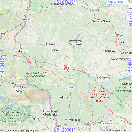
Żary GPS coordinates[2]
51° 38' 31.38" North, 15° 8' 14.172" East
| Map corner | latitude | longitude |
|---|---|---|
| Upper-left | 52.07629°, | 14.43415° |
| Center: | 51.64205°, | 15.13727° |
| Lower-right: | 51.20361°, | 15.8404° |
| Map W x H: | 97×97 km | = 60.3×60.3mi |
| max Lat: | 54.83135° ⇑41% North |
| Żary: | 51.64205° |
| min Lat: | ⇓59% South 49.21328° |
| min Long | Żary | max Long |
| 14.20249° | 15.13727° | 24.03723° |
| W 2.9%⇐ | ⇒97.1% E |
Elevation
Elevation of Żary is 152 m = 499 ft, and this is 39.4 m = 129 ft below average elevation for this country.
| Max E: |
974 m = 3196 ft | 57.6% |
| Avg. | 191.4 m = 628 ft | |
| Żary | 152 m = 499 ft | |
Min E: |
-3 m = -10 ft | 42.4% |
See also: Poland elevation on elevation.city.
Geographical zone
Żary is located in North temperate zone (between Tropic of Cancer and the Arctic Circle). Distance of this North polar circle is 1659.1 km =1030.9 mi to North.| Distance of | km | miles | from Żary |
|---|---|---|---|
| North Pole | 4265 | 2650.1 | to North |
| Arctic Circle | 1659.1 | 1030.9 | to North |
| Tropic Cancer | 3136.1 | 1948.7 | to South |
| Equator | 5742.1 | 3568 | to South |


Nearby cities:
15 places around Żary: (largest is in red/bold)
• Brzeźnica
19.4 km =12.1 mi,  65°
65°
• Gozdnica
23 km =14.3 mi,  186°
186°
• Iłowa
16.3 km =10.1 mi,  164°
164°
• Jasień
14.8 km =9.2 mi,  325°
325°
• Kunice Żarskie
5.1 km =3.2 mi, 158°
• Lipinki Łużyckie
9.6 km =6 mi,  268°
268°
• Lubsko
19.5 km =12.1 mi,  324°
324°
• Małomice
23.6 km =14.7 mi,  113°
113°
• Nowogród Bobrzański
18.7 km =11.6 mi,  21°
21°
• Przewóz
22.1 km =13.7 mi,  215°
215°
• Sieniawa Żarska
5.3 km =3.3 mi, 267°
• Trzebiel
22.2 km =13.8 mi, 267°
• Tuplice
21.6 km =13.4 mi,  280°
280°
• Wymiarki
15.1 km =9.4 mi, 194°
• Żagań
12.6 km =7.8 mi,  102°
102°
Sources, notices
• [Note1] Compared only with cities in Poland existing in our database
• [Src1] Map data: © OpenStreetMap contributors (CC-BY-SA)
• [Src2] Other city data from geonames.org with taken over terms of usage.
• [Src3] Geographical zone / Annual Mean Temperature by Robert A. Rohde @ Wikipedia
