Libertów geodata
Libertów (Lesser Poland) is a populated place; located in Poland in Europe/Warsaw (GMT+2) time zone. With population of 1,952 people, there are 1518 cities with bigger population in this country. Compared to other cities in Poland, 84.2% of cities are located further ↑North; 56.8% of cities are located further ←West and 88.6% of cities have lower elevation than Libertów. Note1


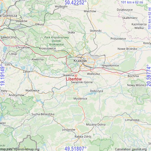
Libertów GPS coordinates[2]
49° 58' 20.712" North, 19° 53' 40.596" East
| Map corner | latitude | longitude |
|---|---|---|
| Upper-left | 50.42252°, | 19.19149° |
| Center: | 49.97242°, | 19.89461° |
| Lower-right: | 49.51807°, | 20.59774° |
| Map W x H: | 100.6×100.6 km | = 62.5×62.5mi |
| max Lat: | 54.83135° ⇑84.2% North |
| Libertów: | 49.97242° |
| min Lat: | ⇓15.8% South 49.21328° |
| min Long | Libertów | max Long |
| 14.20249° | 19.89461° | 24.03723° |
| W 56.8%⇐ | ⇒43.2% E |
Elevation
Elevation of Libertów is 314 m = 1030 ft, and this is 122.6 m = 402 ft above average elevation for this country.
| Max E: |
974 m = 3196 ft | 11.4% |
| Libertów | 314 m 1030 ft | |
| Avg. | 191.4 m = 628 ft | |
Min E: |
-3 m = -10 ft | 88.6% |
See also: Poland elevation on elevation.city.
Geographical zone
Libertów is located in North temperate zone (between Tropic of Cancer and the Arctic Circle). Distance of this North polar circle is 1844.8 km =1146.3 mi to North.| Distance of | km | miles | from Libertów |
|---|---|---|---|
| North Pole | 4450.6 | 2765.5 | to North |
| Arctic Circle | 1844.8 | 1146.3 | to North |
| Tropic Cancer | 2950.5 | 1833.4 | to South |
| Equator | 5556.4 | 3452.6 | to South |


Nearby cities:
15 places around Libertów: (largest is in red/bold)
• Borek Szlachecki
8.6 km =5.3 mi,  264°
264°
• Buków
4.5 km =2.8 mi,  229°
229°
• Konary
3.7 km =2.3 mi,  147°
147°
• Kopanka
7.4 km =4.6 mi,  279°
279°
• Lusina
2.6 km =1.6 mi,  97°
97°
• Mogilany
3.7 km =2.3 mi,  185°
185°
• Ochojno
6.1 km =3.8 mi,  111°
111°
• Radziszów
7 km =4.3 mi, 234°
• Rzeszotary
6.3 km =3.9 mi,  117°
117°
• Rzozów
7.3 km =4.5 mi,  253°
253°
• Sidzina
2.2 km =1.4 mi,  319°
319°
• Siepraw
7.9 km =4.9 mi,  144°
144°
• Skawina
4.7 km =2.9 mi,  273°
273°
• Wrząsowice
4 km =2.5 mi, 112°
• Świątniki Górne
6 km =3.7 mi, 135°
Sources, notices
• [Note1] Compared only with cities in Poland existing in our database
• [Src1] Map data: © OpenStreetMap contributors (CC-BY-SA)
• [Src2] Other city data from geonames.org with taken over terms of usage.
• [Src3] Geographical zone / Annual Mean Temperature by Robert A. Rohde @ Wikipedia
