Wrząsowice geodata
Wrząsowice (Lesser Poland) is a populated place; located in Poland in Europe/Warsaw (GMT+2) time zone. With population of 1,865 people, there are 1574 cities with bigger population in this country. Compared to other cities in Poland, 85% of cities are located further ↑North; 57.5% of cities are located further ←West and 86.9% of cities have lower elevation than Wrząsowice. Note1
Administrative division(s):
- Level 1: Lesser Poland
- Level 2: Powiat krakowski
- Level 3: Świątniki Górne


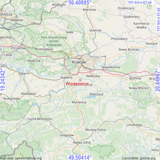
Wrząsowice GPS coordinates[2]
49° 57' 31.032" North, 19° 56' 47.544" East
| Map corner | latitude | longitude |
|---|---|---|
| Upper-left | 50.40885°, | 19.24342° |
| Center: | 49.95862°, | 19.94654° |
| Lower-right: | 49.50414°, | 20.64967° |
| Map W x H: | 100.6×100.6 km | = 62.5×62.5mi |
| max Lat: | 54.83135° ⇑85% North |
| Wrząsowice: | 49.95862° |
| min Lat: | ⇓15% South 49.21328° |
| min Long | Wrząsowice | max Long |
| 14.20249° | 19.94654° | 24.03723° |
| W 57.5%⇐ | ⇒42.5% E |
Elevation
Elevation of Wrząsowice is 300 m = 984 ft, and this is 108.6 m = 356 ft above average elevation for this country.
| Max E: |
974 m = 3196 ft | 13.1% |
| Wrząsowice | 300 m 984 ft | |
| Avg. | 191.4 m = 628 ft | |
Min E: |
-3 m = -10 ft | 86.9% |
See also: Poland elevation on elevation.city.
Geographical zone
Wrząsowice is located in North temperate zone (between Tropic of Cancer and the Arctic Circle). Distance of this North polar circle is 1846.3 km =1147.2 mi to North.| Distance of | km | miles | from Wrząsowice |
|---|---|---|---|
| North Pole | 4452.2 | 2766.5 | to North |
| Arctic Circle | 1846.3 | 1147.2 | to North |
| Tropic Cancer | 2949 | 1832.4 | to South |
| Equator | 5554.9 | 3451.7 | to South |


Nearby cities:
15 places around Wrząsowice: (largest is in red/bold)
• Buków
7.3 km =4.5 mi,  258°
258°
• Głogoczów
8.8 km =5.5 mi,  216°
216°
• Konary
2.3 km =1.4 mi,  228°
228°
• Krzyszkowice
8.5 km =5.3 mi,  191°
191°
• Libertów
4 km =2.5 mi,  292°
292°
• Lusina
1.6 km =1 mi,  316°
316°
• Mogilany
4.6 km =2.9 mi,  241°
241°
• Ochojno
2.1 km =1.3 mi,  108°
108°
• Pawlikowice
7.8 km =4.8 mi,  94°
94°
• Rzeszotary
2.3 km =1.4 mi,  126°
126°
• Sidzina
6 km =3.7 mi,  301°
301°
• Siepraw
5 km =3.1 mi,  170°
170°
• Skawina
8.6 km =5.3 mi,  282°
282°
• Wieliczka
9 km =5.6 mi,  69°
69°
• Świątniki Górne
2.8 km =1.7 mi, 169°
Sources, notices
• [Note1] Compared only with cities in Poland existing in our database
• [Src1] Map data: © OpenStreetMap contributors (CC-BY-SA)
• [Src2] Other city data from geonames.org with taken over terms of usage.
• [Src3] Geographical zone / Annual Mean Temperature by Robert A. Rohde @ Wikipedia
