Mogilany geodata
Mogilany (Lesser Poland) is a seat of a third-order administrative division; located in Poland in Europe/Warsaw (GMT+2) time zone. With population of 2,605 people, there are 1200 cities with bigger population in this country. Compared to other cities in Poland, 86.1% of cities are located further ↑North; 56.7% of cities are located further ←West and 92.1% of cities have lower elevation than Mogilany. Note1


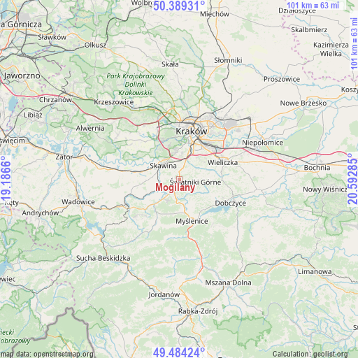
Mogilany GPS coordinates[2]
49° 56' 20.04" North, 19° 53' 22.992" East
| Map corner | latitude | longitude |
|---|---|---|
| Upper-left | 50.38931°, | 19.1866° |
| Center: | 49.9389°, | 19.88972° |
| Lower-right: | 49.48424°, | 20.59285° |
| Map W x H: | 100.6×100.6 km | = 62.5×62.5mi |
| max Lat: | 54.83135° ⇑86.1% North |
| Mogilany: | 49.9389° |
| min Lat: | ⇓13.9% South 49.21328° |
| min Long | Mogilany | max Long |
| 14.20249° | 19.88972° | 24.03723° |
| W 56.7%⇐ | ⇒43.3% E |
Elevation
Elevation of Mogilany is 358 m = 1175 ft, and this is 166.6 m = 547 ft above average elevation for this country.
| Max E: |
974 m = 3196 ft | 7.9% |
| Mogilany | 358 m 1175 ft | |
| Avg. | 191.4 m = 628 ft | |
Min E: |
-3 m = -10 ft | 92.1% |
See also: Poland elevation on elevation.city.
Geographical zone
Mogilany is located in North temperate zone (between Tropic of Cancer and the Arctic Circle). Distance of this North polar circle is 1848.5 km =1148.6 mi to North.| Distance of | km | miles | from Mogilany |
|---|---|---|---|
| North Pole | 4454.4 | 2767.8 | to North |
| Arctic Circle | 1848.5 | 1148.6 | to North |
| Tropic Cancer | 2946.8 | 1831.1 | to South |
| Equator | 5552.7 | 3450.3 | to South |


Nearby cities:
15 places around Mogilany: (largest is in red/bold)
• Buków
3.2 km =2 mi,  284°
284°
• Głogoczów
5.1 km =3.2 mi,  192°
192°
• Konary
2.4 km =1.5 mi,  74°
74°
• Krzyszkowice
6.6 km =4.1 mi,  158°
158°
• Krzywaczka
6.5 km =4 mi,  219°
219°
• Libertów
3.7 km =2.3 mi,  5°
5°
• Lusina
4.5 km =2.8 mi,  41°
41°
• Ochojno
6.3 km =3.9 mi,  75°
75°
• Radziszów
5.3 km =3.3 mi,  265°
265°
• Rzeszotary
6 km =3.7 mi, 82°
• Sidzina
5.5 km =3.4 mi,  348°
348°
• Siepraw
5.6 km =3.5 mi,  118°
118°
• Skawina
5.9 km =3.7 mi,  312°
312°
• Wrząsowice
4.6 km =2.9 mi,  61°
61°
• Świątniki Górne
4.6 km =2.9 mi,  96°
96°
Sources, notices
• [Note1] Compared only with cities in Poland existing in our database
• [Src1] Map data: © OpenStreetMap contributors (CC-BY-SA)
• [Src2] Other city data from geonames.org with taken over terms of usage.
• [Src3] Geographical zone / Annual Mean Temperature by Robert A. Rohde @ Wikipedia
