Przyrów geodata
Przyrów (Silesia) is a populated place; located in Poland in Europe/Warsaw (GMT+2) time zone. With population of 1,222 people, there are 2148 cities with bigger population in this country. Compared to other cities in Poland, 60.2% of cities are located further ↑North; 50.6% of cities are located further →East and 71.6% of cities have lower elevation than Przyrów. Note1


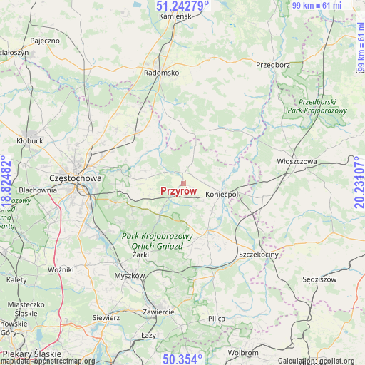
Przyrów GPS coordinates[2]
50° 48' 1.836" North, 19° 31' 40.584" East
| Map corner | latitude | longitude |
|---|---|---|
| Upper-left | 51.24279°, | 18.82482° |
| Center: | 50.80051°, | 19.52794° |
| Lower-right: | 50.354°, | 20.23107° |
| Map W x H: | 98.8×98.8 km | = 61.4×61.4mi |
| max Lat: | 54.83135° ⇑60.2% North |
| Przyrów: | 50.80051° |
| min Lat: | ⇓39.8% South 49.21328° |
| min Long | Przyrów | max Long |
| 14.20249° | 19.52794° | 24.03723° |
| W 49.4%⇐ | ⇒50.6% E |
Elevation
Elevation of Przyrów is 234 m = 768 ft, and this is 42.6 m = 140 ft above average elevation for this country.
| Max E: |
974 m = 3196 ft | 28.4% |
| Przyrów | 234 m 768 ft | |
| Avg. | 191.4 m = 628 ft | |
Min E: |
-3 m = -10 ft | 71.6% |
See also: Poland elevation on elevation.city.
Geographical zone
Przyrów is located in North temperate zone (between Tropic of Cancer and the Arctic Circle). Distance of this North polar circle is 1752.7 km =1089.1 mi to North.| Distance of | km | miles | from Przyrów |
|---|---|---|---|
| North Pole | 4358.6 | 2708.3 | to North |
| Arctic Circle | 1752.7 | 1089.1 | to North |
| Tropic Cancer | 3042.6 | 1890.6 | to South |
| Equator | 5648.5 | 3509.8 | to South |


Nearby cities:
15 places around Przyrów: (largest is in red/bold)
• Drochlin
11.2 km =7 mi,  135°
135°
• Dąbrowa Zielona
5.2 km =3.2 mi,  22°
22°
• Dąbrowno
14.4 km =8.9 mi,  176°
176°
• Gidle
18.4 km =11.4 mi,  347°
347°
• Janów
10.9 km =6.8 mi,  217°
217°
• Koniecpol
11.7 km =7.3 mi,  104°
104°
• Kłomnice
18 km =11.2 mi,  318°
318°
• Lelów
14.7 km =9.1 mi,  152°
152°
• Mstów
17.3 km =10.7 mi,  280°
280°
• Niegowa
18 km =11.2 mi,  189°
189°
• Potok Złoty
12.5 km =7.8 mi,  213°
213°
• Siedlec
16.5 km =10.3 mi, 223°
• Soborzyce
9 km =5.6 mi,  43°
43°
• Sokolniki
18.6 km =11.6 mi,  164°
164°
• Żytno
15.7 km =9.8 mi,  26°
26°
Sources, notices
• [Note1] Compared only with cities in Poland existing in our database
• [Src1] Map data: © OpenStreetMap contributors (CC-BY-SA)
• [Src2] Other city data from geonames.org with taken over terms of usage.
• [Src3] Geographical zone / Annual Mean Temperature by Robert A. Rohde @ Wikipedia
