Pilica geodata
Pilica (Silesia) is a populated place; located in Poland in Europe/Warsaw (GMT+2) time zone. With population of 1,999 people, there are 1502 cities with bigger population in this country. Compared to other cities in Poland, 67.8% of cities are located further ↑North; 51.9% of cities are located further ←West and 91% of cities have lower elevation than Pilica. Note1


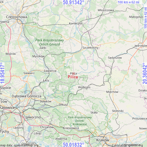
Pilica GPS coordinates[2]
50° 28' 4.764" North, 19° 39' 26.244" East
| Map corner | latitude | longitude |
|---|---|---|
| Upper-left | 50.91342°, | 18.95417° |
| Center: | 50.46799°, | 19.65729° |
| Lower-right: | 50.01832°, | 20.36042° |
| Map W x H: | 99.5×99.5 km | = 61.8×61.8mi |
| max Lat: | 54.83135° ⇑67.8% North |
| Pilica: | 50.46799° |
| min Lat: | ⇓32.2% South 49.21328° |
| min Long | Pilica | max Long |
| 14.20249° | 19.65729° | 24.03723° |
| W 51.9%⇐ | ⇒48.1% E |
Elevation
Elevation of Pilica is 343 m = 1125 ft, and this is 151.6 m = 497 ft above average elevation for this country.
| Max E: |
974 m = 3196 ft | 9% |
| Pilica | 343 m 1125 ft | |
| Avg. | 191.4 m = 628 ft | |
Min E: |
-3 m = -10 ft | 91% |
See also: Poland elevation on elevation.city.
Geographical zone
Pilica is located in North temperate zone (between Tropic of Cancer and the Arctic Circle). Distance of this North polar circle is 1789.7 km =1112.1 mi to North.| Distance of | km | miles | from Pilica |
|---|---|---|---|
| North Pole | 4395.5 | 2731.2 | to North |
| Arctic Circle | 1789.7 | 1112.1 | to North |
| Tropic Cancer | 3005.6 | 1867.6 | to South |
| Equator | 5611.5 | 3486.8 | to South |


Nearby cities:
15 places around Pilica: (largest is in red/bold)
• Irządze
17.8 km =11.1 mi,  6°
6°
• Klucze
16.2 km =10.1 mi,  204°
204°
• Kroczyce
12.1 km =7.5 mi,  329°
329°
• Ogrodzieniec
9.9 km =6.2 mi,  259°
259°
• Poręba Górna
15.8 km =9.8 mi,  143°
143°
• Rokitno
15.7 km =9.8 mi,  34°
34°
• Rokitno Szlacheckie
16.4 km =10.2 mi, 255°
• Rudniki
17.1 km =10.6 mi,  290°
290°
• Wierzchowisko
15.2 km =9.4 mi,  132°
132°
• Wolbrom
12.2 km =7.6 mi, 143°
• Włodowice
17.5 km =10.9 mi,  303°
303°
• Zarzecze
11.5 km =7.1 mi,  166°
166°
• Zawiercie
17.2 km =10.7 mi,  277°
277°
• Zdów
17.7 km =11 mi, 328°
• Żarnowiec
14.5 km =9 mi,  85°
85°
Sources, notices
• [Note1] Compared only with cities in Poland existing in our database
• [Src1] Map data: © OpenStreetMap contributors (CC-BY-SA)
• [Src2] Other city data from geonames.org with taken over terms of usage.
• [Src3] Geographical zone / Annual Mean Temperature by Robert A. Rohde @ Wikipedia
