Rudniki geodata
Rudniki (Silesia) is a populated place; located in Poland in Europe/Warsaw (GMT+2) time zone. With population of 1,338 people, there are 2027 cities with bigger population in this country. Compared to other cities in Poland, 66.8% of cities are located further ↑North; 52.2% of cities are located further →East and 91.8% of cities have lower elevation than Rudniki. Note1


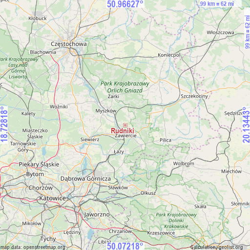
Rudniki GPS coordinates[2]
50° 31' 16.824" North, 19° 25' 52.68" East
| Map corner | latitude | longitude |
|---|---|---|
| Upper-left | 50.96627°, | 18.72818° |
| Center: | 50.52134°, | 19.4313° |
| Lower-right: | 50.07218°, | 20.13443° |
| Map W x H: | 99.4×99.4 km | = 61.8×61.8mi |
| max Lat: | 54.83135° ⇑66.8% North |
| Rudniki: | 50.52134° |
| min Lat: | ⇓33.2% South 49.21328° |
| min Long | Rudniki | max Long |
| 14.20249° | 19.4313° | 24.03723° |
| W 47.8%⇐ | ⇒52.2% E |
Elevation
Elevation of Rudniki is 354 m = 1161 ft, and this is 162.6 m = 533 ft above average elevation for this country.
| Max E: |
974 m = 3196 ft | 8.2% |
| Rudniki | 354 m 1161 ft | |
| Avg. | 191.4 m = 628 ft | |
Min E: |
-3 m = -10 ft | 91.8% |
See also: Poland elevation on elevation.city.
Geographical zone
Rudniki is located in North temperate zone (between Tropic of Cancer and the Arctic Circle). Distance of this North polar circle is 1783.7 km =1108.3 mi to North.| Distance of | km | miles | from Rudniki |
|---|---|---|---|
| North Pole | 4389.6 | 2727.6 | to North |
| Arctic Circle | 1783.7 | 1108.3 | to North |
| Tropic Cancer | 3011.5 | 1871.3 | to South |
| Equator | 5617.4 | 3490.5 | to South |


Nearby cities:
15 places around Rudniki: (largest is in red/bold)
• Ciągowice
9.5 km =5.9 mi,  209°
209°
• Góra Włodowska
6.3 km =3.9 mi,  10°
10°
• Jaworznik
9.8 km =6.1 mi,  350°
350°
• Kroczyce
10.8 km =6.7 mi,  65°
65°
• Myszków
9.6 km =6 mi,  308°
308°
• Niegowa
13.8 km =8.6 mi,  15°
15°
• Ogrodzieniec
10 km =6.2 mi,  140°
140°
• Poręba
7.5 km =4.7 mi,  240°
240°
• Rokitno Szlacheckie
9.9 km =6.2 mi,  179°
179°
• Wysoka
11.6 km =7.2 mi, 208°
• Włodowice
4.1 km =2.5 mi, 20°
• Zawiercie
3.9 km =2.4 mi,  195°
195°
• Zdów
11.5 km =7.1 mi,  36°
36°
• Łazy
10.7 km =6.6 mi,  193°
193°
• Żarki
12.5 km =7.8 mi,  337°
337°
Sources, notices
• [Note1] Compared only with cities in Poland existing in our database
• [Src1] Map data: © OpenStreetMap contributors (CC-BY-SA)
• [Src2] Other city data from geonames.org with taken over terms of usage.
• [Src3] Geographical zone / Annual Mean Temperature by Robert A. Rohde @ Wikipedia
