Jedlina-Zdrój geodata
Jedlina-Zdrój (Lower Silesia) is a seat of a third-order administrative division; located in Poland in Europe/Warsaw (GMT+2) time zone. With population of 5,062 people, there are 683 cities with bigger population in this country. Compared to other cities in Poland, 62.4% of cities are located further ↑North; 90.6% of cities are located further →East and 96.2% of cities have lower elevation than Jedlina-Zdrój. Note1
Administrative division(s):
- Level 1: Lower Silesia
- Level 2: Powiat wałbrzyski
- Level 3: Jedlina-Zdrój


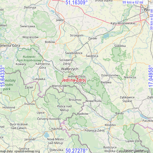
Jedlina-Zdrój GPS coordinates[2]
50° 43' 12.18" North, 16° 20' 47.22" East
| Map corner | latitude | longitude |
|---|---|---|
| Upper-left | 51.16309°, | 15.64333° |
| Center: | 50.72005°, | 16.34645° |
| Lower-right: | 50.27278°, | 17.04958° |
| Map W x H: | 99×99 km | = 61.5×61.5mi |
| max Lat: | 54.83135° ⇑62.4% North |
| Jedlina-Zdrój: | 50.72005° |
| min Lat: | ⇓37.6% South 49.21328° |
| min Long | Jedlina-Zdrój | max Long |
| 14.20249° | 16.34645° | 24.03723° |
| W 9.4%⇐ | ⇒90.6% E |
Elevation
Elevation of Jedlina-Zdrój is 448 m = 1470 ft, and this is 256.6 m = 842 ft above average elevation for this country.
| Max E: |
974 m = 3196 ft | 3.8% |
| Jedlina-Zdrój | 448 m 1470 ft | |
| Avg. | 191.4 m = 628 ft | |
Min E: |
-3 m = -10 ft | 96.2% |
See also: Poland elevation on elevation.city.
Geographical zone
Jedlina-Zdrój is located in North temperate zone (between Tropic of Cancer and the Arctic Circle). Distance of this North polar circle is 1761.6 km =1094.6 mi to North.| Distance of | km | miles | from Jedlina-Zdrój |
|---|---|---|---|
| North Pole | 4367.5 | 2713.8 | to North |
| Arctic Circle | 1761.6 | 1094.6 | to North |
| Tropic Cancer | 3033.6 | 1885 | to South |
| Equator | 5639.5 | 3504.2 | to South |


Nearby cities:
15 places around Jedlina-Zdrój: (largest is in red/bold)
• Boguszów-Gorce
10.7 km =6.6 mi,  291°
291°
• Czarny Bór
16.2 km =10.1 mi, 290°
• Dziećmorowice
5.5 km =3.4 mi,  4°
4°
• Głuszyca
4 km =2.5 mi,  153°
153°
• Głuszyca Górna
6.4 km =4 mi,  160°
160°
• Jugów
15.9 km =9.9 mi,  130°
130°
• Ludwikowice Kłodzkie
13.3 km =8.3 mi,  142°
142°
• Mieroszów
12.6 km =7.8 mi,  241°
241°
• Pieszyce
16.6 km =10.3 mi,  92°
92°
• Stare Bogaczowice
17.8 km =11.1 mi,  322°
322°
• Szczawno-Zdrój
11.2 km =7 mi,  325°
325°
• Walim
7.4 km =4.6 mi,  109°
109°
• Wałbrzych
7.2 km =4.5 mi, 322°
• Świdnica
17 km =10.6 mi,  35°
35°
• Świebodzice
15.6 km =9.7 mi,  353°
353°
In other languages:
- In German: Bad Charlottenbrunn, Charlottenbrunn, Bad Charlottenbrunn in Schlesien
- In Russian: Едлина-Здруй
- In Chinese: 耶德利納-茲德魯伊
Sources, notices
• [Note1] Compared only with cities in Poland existing in our database
• [Src1] Map data: © OpenStreetMap contributors (CC-BY-SA)
• [Src2] Other city data from geonames.org with taken over terms of usage.
• [Src3] Geographical zone / Annual Mean Temperature by Robert A. Rohde @ Wikipedia
