Stare Bogaczowice geodata
Stare Bogaczowice (Lower Silesia) is a populated place; located in Poland in Europe/Warsaw (GMT+2) time zone. With population of 1,450 people, there are 1914 cities with bigger population in this country. Compared to other cities in Poland, 59.2% of cities are located further ↑North; 91.4% of cities are located further →East and 92.8% of cities have lower elevation than Stare Bogaczowice. Note1
Administrative division(s):
- Level 1: Lower Silesia
- Level 2: Powiat wałbrzyski
- Level 3: Stare Bogaczowice


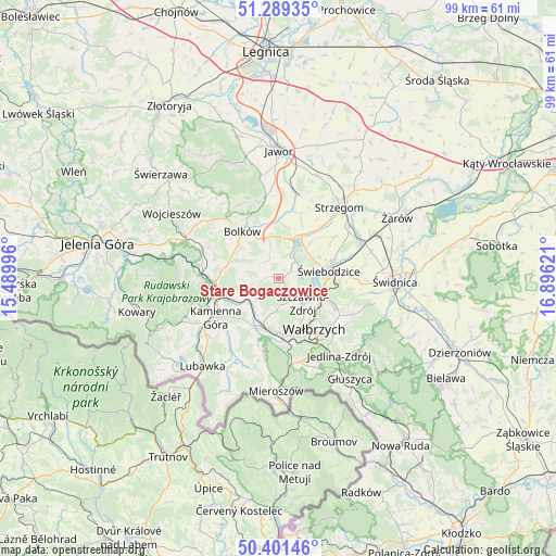
Stare Bogaczowice GPS coordinates[2]
50° 50' 51.072" North, 16° 11' 35.088" East
| Map corner | latitude | longitude |
|---|---|---|
| Upper-left | 51.28935°, | 15.48996° |
| Center: | 50.84752°, | 16.19308° |
| Lower-right: | 50.40146°, | 16.89621° |
| Map W x H: | 98.7×98.7 km | = 61.3×61.3mi |
| max Lat: | 54.83135° ⇑59.2% North |
| Stare Bogaczowice: | 50.84752° |
| min Lat: | ⇓40.8% South 49.21328° |
| min Long | Stare Bogaczowi | max Long |
| 14.20249° | 16.19308° | 24.03723° |
| W 8.6%⇐ | ⇒91.4% E |
Elevation
Elevation of Stare Bogaczowice is 367 m = 1204 ft, and this is 175.6 m = 576 ft above average elevation for this country.
| Max E: |
974 m = 3196 ft | 7.2% |
| Stare Bogaczowice | 367 m 1204 ft | |
| Avg. | 191.4 m = 628 ft | |
Min E: |
-3 m = -10 ft | 92.8% |
See also: Poland elevation on elevation.city.
Geographical zone
Stare Bogaczowice is located in North temperate zone (between Tropic of Cancer and the Arctic Circle). Distance of this North polar circle is 1747.5 km =1085.8 mi to North.| Distance of | km | miles | from Stare Bogaczowice |
|---|---|---|---|
| North Pole | 4353.3 | 2705 | to North |
| Arctic Circle | 1747.5 | 1085.8 | to North |
| Tropic Cancer | 3047.8 | 1893.8 | to South |
| Equator | 5653.7 | 3513 | to South |


Nearby cities:
15 places around Stare Bogaczowice: (largest is in red/bold)
• Boguszów-Gorce
10.3 km =6.4 mi,  175°
175°
• Bolków
10.5 km =6.5 mi,  322°
322°
• Czarny Bór
9.6 km =6 mi,  207°
207°
• Dobromierz
7.9 km =4.9 mi,  25°
25°
• Dziećmorowice
14.1 km =8.8 mi,  127°
127°
• Jedlina-Zdrój
17.8 km =11.1 mi,  142°
142°
• Kamienna Góra
13.5 km =8.4 mi,  237°
237°
• Krzeszów
15.3 km =9.5 mi, 214°
• Marciszów
12.1 km =7.5 mi,  268°
268°
• Stanowice
15.7 km =9.8 mi,  53°
53°
• Strzegom
16.9 km =10.5 mi,  40°
40°
• Szczawno-Zdrój
6.6 km =4.1 mi, 137°
• Wałbrzych
10.6 km =6.6 mi, 142°
• Wierzchosławice
8.6 km =5.3 mi,  304°
304°
• Świebodzice
9 km =5.6 mi,  81°
81°
Sources, notices
• [Note1] Compared only with cities in Poland existing in our database
• [Src1] Map data: © OpenStreetMap contributors (CC-BY-SA)
• [Src2] Other city data from geonames.org with taken over terms of usage.
• [Src3] Geographical zone / Annual Mean Temperature by Robert A. Rohde @ Wikipedia
