Dziećmorowice geodata
Dziećmorowice (Lower Silesia) is a populated place; located in Poland in Europe/Warsaw (GMT+2) time zone. With population of 1,162 people, there are 2243 cities with bigger population in this country. Compared to other cities in Poland, 60.9% of cities are located further ↑North; 90.5% of cities are located further →East and 95.4% of cities have lower elevation than Dziećmorowice. Note1


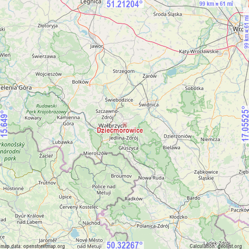
Dziećmorowice GPS coordinates[2]
50° 46' 10.092" North, 16° 21' 7.632" East
| Map corner | latitude | longitude |
|---|---|---|
| Upper-left | 51.21204°, | 15.649° |
| Center: | 50.76947°, | 16.35212° |
| Lower-right: | 50.32267°, | 17.05525° |
| Map W x H: | 98.9×98.9 km | = 61.5×61.5mi |
| max Lat: | 54.83135° ⇑60.9% North |
| Dziećmorowice: | 50.76947° |
| min Lat: | ⇓39.1% South 49.21328° |
| min Long | Dziećmorowice | max Long |
| 14.20249° | 16.35212° | 24.03723° |
| W 9.5%⇐ | ⇒90.5% E |
Elevation
Elevation of Dziećmorowice is 425 m = 1394 ft, and this is 233.6 m = 766 ft above average elevation for this country.
| Max E: |
974 m = 3196 ft | 4.6% |
| Dziećmorowice | 425 m 1394 ft | |
| Avg. | 191.4 m = 628 ft | |
Min E: |
-3 m = -10 ft | 95.4% |
See also: Poland elevation on elevation.city.
Geographical zone
Dziećmorowice is located in North temperate zone (between Tropic of Cancer and the Arctic Circle). Distance of this North polar circle is 1756.1 km =1091.2 mi to North.| Distance of | km | miles | from Dziećmorowice |
|---|---|---|---|
| North Pole | 4362 | 2710.4 | to North |
| Arctic Circle | 1756.1 | 1091.2 | to North |
| Tropic Cancer | 3039.1 | 1888.4 | to South |
| Equator | 5645 | 3507.6 | to South |


Nearby cities:
15 places around Dziećmorowice: (largest is in red/bold)
• Boguszów-Gorce
10.5 km =6.5 mi,  261°
261°
• Czarny Bór
15.6 km =9.7 mi,  270°
270°
• Dobromierz
17.6 km =10.9 mi,  333°
333°
• Głuszyca
9.2 km =5.7 mi,  171°
171°
• Głuszyca Górna
11.6 km =7.2 mi, 171°
• Jaworzyna Śląska
17 km =10.6 mi,  19°
19°
• Jedlina-Zdrój
5.5 km =3.4 mi,  184°
184°
• Mieroszów
16.3 km =10.1 mi,  224°
224°
• Pieszyce
17.4 km =10.8 mi,  111°
111°
• Stare Bogaczowice
14.1 km =8.8 mi,  307°
307°
• Szczawno-Zdrój
7.7 km =4.8 mi,  299°
299°
• Walim
10.3 km =6.4 mi,  140°
140°
• Wałbrzych
4.8 km =3 mi, 272°
• Świdnica
12.7 km =7.9 mi,  49°
49°
• Świebodzice
10.3 km =6.4 mi,  347°
347°
Sources, notices
• [Note1] Compared only with cities in Poland existing in our database
• [Src1] Map data: © OpenStreetMap contributors (CC-BY-SA)
• [Src2] Other city data from geonames.org with taken over terms of usage.
• [Src3] Geographical zone / Annual Mean Temperature by Robert A. Rohde @ Wikipedia
