Świebodzice geodata
Świebodzice (Lower Silesia) is a seat of a third-order administrative division; located in Poland in Europe/Warsaw (GMT+2) time zone. With population of 23,228 people, there are 210 cities with bigger population in this country. Compared to other cities in Poland, 58.8% of cities are located further ↑North; 90.6% of cities are located further →East and 82.5% of cities have lower elevation than Świebodzice. Note1


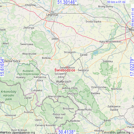
Świebodzice GPS coordinates[2]
50° 51' 35.064" North, 16° 19' 10.776" East
| Map corner | latitude | longitude |
|---|---|---|
| Upper-left | 51.30146°, | 15.61654° |
| Center: | 50.85974°, | 16.31966° |
| Lower-right: | 50.4138°, | 17.02279° |
| Map W x H: | 98.7×98.7 km | = 61.3×61.3mi |
| max Lat: | 54.83135° ⇑58.8% North |
| Świebodzice: | 50.85974° |
| min Lat: | ⇓41.2% South 49.21328° |
| min Long | Świebodzice | max Long |
| 14.20249° | 16.31966° | 24.03723° |
| W 9.4%⇐ | ⇒90.6% E |
Elevation
Elevation of Świebodzice is 278 m = 912 ft, and this is 86.6 m = 284 ft above average elevation for this country.
| Max E: |
974 m = 3196 ft | 17.5% |
| Świebodzice | 278 m 912 ft | |
| Avg. | 191.4 m = 628 ft | |
Min E: |
-3 m = -10 ft | 82.5% |
See also: Poland elevation on elevation.city.
Geographical zone
Świebodzice is located in North temperate zone (between Tropic of Cancer and the Arctic Circle). Distance of this North polar circle is 1746.1 km =1085 mi to North.| Distance of | km | miles | from Świebodzice |
|---|---|---|---|
| North Pole | 4352 | 2704.2 | to North |
| Arctic Circle | 1746.1 | 1085 | to North |
| Tropic Cancer | 3049.2 | 1894.7 | to South |
| Equator | 5655.1 | 3513.9 | to South |


Nearby cities:
15 places around Świebodzice: (largest is in red/bold)
• Boguszów-Gorce
14.2 km =8.8 mi,  214°
214°
• Bolków
16.8 km =10.4 mi,  294°
294°
• Czarny Bór
16.6 km =10.3 mi,  233°
233°
• Dobromierz
7.9 km =4.9 mi,  316°
316°
• Dziećmorowice
10.3 km =6.4 mi,  167°
167°
• Jaworzyna Śląska
9.9 km =6.2 mi,  52°
52°
• Jedlina-Zdrój
15.6 km =9.7 mi, 173°
• Stanowice
8.8 km =5.5 mi,  25°
25°
• Stare Bogaczowice
9 km =5.6 mi,  261°
261°
• Strzegom
11.6 km =7.2 mi,  10°
10°
• Szczawno-Zdrój
7.7 km =4.8 mi,  215°
215°
• Wałbrzych
10.1 km =6.3 mi,  194°
194°
• Wierzchosławice
16.4 km =10.2 mi,  282°
282°
• Świdnica
12 km =7.5 mi,  98°
98°
• Żarów
15.2 km =9.4 mi, 53°
Sources, notices
• [Note1] Compared only with cities in Poland existing in our database
• [Src1] Map data: © OpenStreetMap contributors (CC-BY-SA)
• [Src2] Other city data from geonames.org with taken over terms of usage.
• [Src3] Geographical zone / Annual Mean Temperature by Robert A. Rohde @ Wikipedia
