Jaraczewo geodata
Jaraczewo (Greater Poland) is a populated place; located in Poland in Europe/Warsaw (GMT+2) time zone. With population of 1,392 people, there are 2001 cities with bigger population in this country. Compared to other cities in Poland, 65.1% of cities are located further ↓South; 81.4% of cities are located further →East and 78.4% of cities have higher elevation than Jaraczewo. Note1


Jaraczewo GPS coordinates[2]
51° 58' 6.744" North, 17° 17' 49.452" East
| Map corner | latitude | longitude |
|---|---|---|
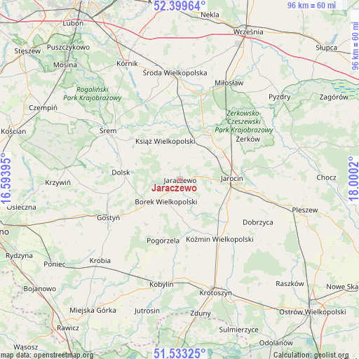
| Upper-left | 52.39964°, | 16.59395° |
| Center: | 51.96854°, | 17.29707° |
| Lower-right: | 51.53325°, | 18.0002° |
| Map W x H: | 96.3×96.3 km | = 59.8×59.8mi |
| max Lat: | 54.83135° ⇑34.9% North |
| Jaraczewo: | 51.96854° |
| min Lat: | ⇓65.1% South 49.21328° |
| min Long | Jaraczewo | max Long |
| 14.20249° | 17.29707° | 24.03723° |
| W 18.6%⇐ | ⇒81.4% E |
Elevation
Elevation of Jaraczewo is 103 m = 338 ft, and this is 88.4 m = 290 ft below average elevation for this country.
| Max E: |
974 m = 3196 ft | 78.4% |
| Avg. | 191.4 m = 628 ft | |
| Jaraczewo | 103 m = 338 ft | |
Min E: |
-3 m = -10 ft | 21.6% |
See also: Poland elevation on elevation.city.
Geographical zone
Jaraczewo is located in North temperate zone (between Tropic of Cancer and the Arctic Circle). Distance of this North polar circle is 1622.8 km =1008.4 mi to North.| Distance of | km | miles | from Jaraczewo |
|---|---|---|---|
| North Pole | 4228.7 | 2627.6 | to North |
| Arctic Circle | 1622.8 | 1008.4 | to North |
| Tropic Cancer | 3172.4 | 1971.2 | to South |
| Equator | 5778.4 | 3590.5 | to South |


Nearby cities:
15 places around Jaraczewo: (largest is in red/bold)
• Borek Wielkopolski
6.9 km =4.3 mi,  213°
213°
• Dolsk
16.1 km =10 mi,  275°
275°
• Golina
14.1 km =8.8 mi,  115°
115°
• Gostyń
21.7 km =13.5 mi,  243°
243°
• Jarocin
14.1 km =8.8 mi,  88°
88°
• Koźmin Wielkopolski
19.1 km =11.9 mi,  145°
145°
• Krzykosy
16.6 km =10.3 mi,  18°
18°
• Książ Wielkopolski
11.1 km =6.9 mi,  339°
339°
• Nowe Miasto nad Wartą
15.6 km =9.7 mi,  30°
30°
• Piaski
18 km =11.2 mi, 238°
• Pogorzela
16.9 km =10.5 mi,  195°
195°
• Solec
15.5 km =9.6 mi,  8°
8°
• Witaszyce
18.4 km =11.4 mi,  99°
99°
• Zakrzew
17.1 km =10.6 mi,  106°
106°
• Żerków
21.4 km =13.3 mi,  58°
58°
Sources, notices
• [Note1] Compared only with cities in Poland existing in our database
• [Src1] Map data: © OpenStreetMap contributors (CC-BY-SA)
• [Src2] Other city data from geonames.org with taken over terms of usage.
• [Src3] Geographical zone / Annual Mean Temperature by Robert A. Rohde @ Wikipedia
