Żerków geodata
Żerków (Greater Poland) is a seat of a third-order administrative division; located in Poland in Europe/Warsaw (GMT+2) time zone. With population of 2,127 people, there are 1398 cities with bigger population in this country. Compared to other cities in Poland, 66.8% of cities are located further ↓South; 79.4% of cities are located further →East and 72.1% of cities have higher elevation than Żerków. Note1


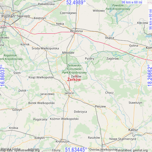
Żerków GPS coordinates[2]
52° 4' 7.572" North, 17° 33' 48.564" East
| Map corner | latitude | longitude |
|---|---|---|
| Upper-left | 52.4989°, | 16.86037° |
| Center: | 52.06877°, | 17.56349° |
| Lower-right: | 51.63445°, | 18.26662° |
| Map W x H: | 96.1×96.1 km | = 59.7×59.7mi |
| max Lat: | 54.83135° ⇑33.2% North |
| Żerków: | 52.06877° |
| min Lat: | ⇓66.8% South 49.21328° |
| min Long | Żerków | max Long |
| 14.20249° | 17.56349° | 24.03723° |
| W 20.6%⇐ | ⇒79.4% E |
Elevation
Elevation of Żerków is 117 m = 384 ft, and this is 74.4 m = 244 ft below average elevation for this country.
| Max E: |
974 m = 3196 ft | 72.1% |
| Avg. | 191.4 m = 628 ft | |
| Żerków | 117 m = 384 ft | |
Min E: |
-3 m = -10 ft | 27.9% |
See also: Poland elevation on elevation.city.
Geographical zone
Żerków is located in North temperate zone (between Tropic of Cancer and the Arctic Circle). Distance of this North polar circle is 1611.7 km =1001.5 mi to North.| Distance of | km | miles | from Żerków |
|---|---|---|---|
| North Pole | 4217.6 | 2620.7 | to North |
| Arctic Circle | 1611.7 | 1001.5 | to North |
| Tropic Cancer | 3183.6 | 1978.2 | to South |
| Equator | 5789.5 | 3597.4 | to South |


Nearby cities:
15 places around Żerków: (largest is in red/bold)
• Dobieszczyzna
8.8 km =5.5 mi,  121°
121°
• Gizałki
14.4 km =8.9 mi,  101°
101°
• Golina
18 km =11.2 mi,  197°
197°
• Jarocin
11.5 km =7.1 mi, 201°
• Kotlin
17.6 km =10.9 mi,  160°
160°
• Kołaczkowo
17 km =10.6 mi,  14°
14°
• Krzykosy
13.7 km =8.5 mi,  289°
289°
• Lisewo
9.1 km =5.7 mi,  79°
79°
• Miłosław
15.8 km =9.8 mi,  341°
341°
• Nowe Miasto nad Wartą
10.7 km =6.6 mi,  282°
282°
• Pyzdry
14.2 km =8.8 mi,  37°
37°
• Solec
16.6 km =10.3 mi, 284°
• Tomice
11.9 km =7.4 mi,  91°
91°
• Witaszyce
14.2 km =8.8 mi,  180°
180°
• Zakrzew
16.2 km =10.1 mi,  186°
186°
Sources, notices
• [Note1] Compared only with cities in Poland existing in our database
• [Src1] Map data: © OpenStreetMap contributors (CC-BY-SA)
• [Src2] Other city data from geonames.org with taken over terms of usage.
• [Src3] Geographical zone / Annual Mean Temperature by Robert A. Rohde @ Wikipedia
