Mierzęcice geodata
Mierzęcice (Silesia) is a seat of a third-order administrative division; located in Poland in Europe/Warsaw (GMT+2) time zone. With population of 2,676 people, there are 1176 cities with bigger population in this country. Compared to other cities in Poland, 68.3% of cities are located further ↑North; 57.6% of cities are located further →East and 88.9% of cities have lower elevation than Mierzęcice. Note1


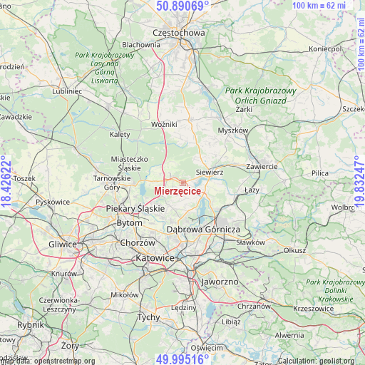
Mierzęcice GPS coordinates[2]
50° 26' 42.144" North, 19° 7' 45.624" East
| Map corner | latitude | longitude |
|---|---|---|
| Upper-left | 50.89069°, | 18.42622° |
| Center: | 50.44504°, | 19.12934° |
| Lower-right: | 49.99516°, | 19.83247° |
| Map W x H: | 99.6×99.6 km | = 61.9×61.9mi |
| max Lat: | 54.83135° ⇑68.3% North |
| Mierzęcice: | 50.44504° |
| min Lat: | ⇓31.7% South 49.21328° |
| min Long | Mierzęcice | max Long |
| 14.20249° | 19.12934° | 24.03723° |
| W 42.4%⇐ | ⇒57.6% E |
Elevation
Elevation of Mierzęcice is 316 m = 1037 ft, and this is 124.6 m = 409 ft above average elevation for this country.
| Max E: |
974 m = 3196 ft | 11.1% |
| Mierzęcice | 316 m 1037 ft | |
| Avg. | 191.4 m = 628 ft | |
Min E: |
-3 m = -10 ft | 88.9% |
See also: Poland elevation on elevation.city.
Geographical zone
Mierzęcice is located in North temperate zone (between Tropic of Cancer and the Arctic Circle). Distance of this North polar circle is 1792.2 km =1113.6 mi to North.| Distance of | km | miles | from Mierzęcice |
|---|---|---|---|
| North Pole | 4398.1 | 2732.9 | to North |
| Arctic Circle | 1792.2 | 1113.6 | to North |
| Tropic Cancer | 3003 | 1866 | to South |
| Equator | 5609 | 3485.3 | to South |


Nearby cities:
15 places around Mierzęcice: (largest is in red/bold)
• Bobrowniki
12.4 km =7.7 mi,  234°
234°
• Będzin
13.2 km =8.2 mi,  181°
181°
• Cynków
13 km =8.1 mi,  356°
356°
• Dobieszowice
9.8 km =6.1 mi,  237°
237°
• Gródków
9.3 km =5.8 mi,  190°
190°
• Ożarowice
6.4 km =4 mi,  287°
287°
• Pińczyce
12.4 km =7.7 mi,  34°
34°
• Psary
7.3 km =4.5 mi, 187°
• Rogoźnik
8.8 km =5.5 mi, 227°
• Sarnów
8.1 km =5 mi,  169°
169°
• Siewierz
7.5 km =4.7 mi,  71°
71°
• Strzyżowice
7.3 km =4.5 mi,  208°
208°
• Sączów
7.1 km =4.4 mi,  261°
261°
• Wojkowice
11.1 km =6.9 mi,  216°
216°
• Wymysłów
10.8 km =6.7 mi,  249°
249°
Sources, notices
• [Note1] Compared only with cities in Poland existing in our database
• [Src1] Map data: © OpenStreetMap contributors (CC-BY-SA)
• [Src2] Other city data from geonames.org with taken over terms of usage.
• [Src3] Geographical zone / Annual Mean Temperature by Robert A. Rohde @ Wikipedia
