Białogard geodata
Białogard (West Pomerania) is a populated place; located in Poland in Europe/Warsaw (GMT+2) time zone. With population of 24,265 people, there are 199 cities with bigger population in this country. Compared to other cities in Poland, 94.3% of cities are located further ↓South; 92.6% of cities are located further →East and 96.6% of cities have higher elevation than Białogard. Note1


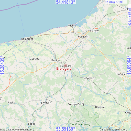
Białogard GPS coordinates[2]
54° 0' 25.056" North, 15° 59' 15.036" East
| Map corner | latitude | longitude |
|---|---|---|
| Upper-left | 54.41813°, | 15.28439° |
| Center: | 54.00696°, | 15.98751° |
| Lower-right: | 53.59169°, | 16.69064° |
| Map W x H: | 91.9×91.9 km | = 57.1×57.1mi |
| max Lat: | 54.83135° ⇑5.7% North |
| Białogard: | 54.00696° |
| min Lat: | ⇓94.3% South 49.21328° |
| min Long | Białogard | max Long |
| 14.20249° | 15.98751° | 24.03723° |
| W 7.4%⇐ | ⇒92.6% E |
Elevation
Elevation of Białogard is 25 m = 82 ft, and this is 166.4 m = 546 ft below average elevation for this country.
| Max E: |
974 m = 3196 ft | 96.6% |
| Avg. | 191.4 m = 628 ft | |
| Białogard | 25 m = 82 ft | |
Min E: |
-3 m = -10 ft | 3.4% |
See also: Poland elevation on elevation.city.
Geographical zone
Białogard is located in North temperate zone (between Tropic of Cancer and the Arctic Circle). Distance of this North polar circle is 1396.2 km =867.6 mi to North.| Distance of | km | miles | from Białogard |
|---|---|---|---|
| North Pole | 4002.1 | 2486.8 | to North |
| Arctic Circle | 1396.2 | 867.6 | to North |
| Tropic Cancer | 3399.1 | 2112.1 | to South |
| Equator | 6005 | 3731.3 | to South |


Nearby cities:
15 places around Białogard: (largest is in red/bold)
• Biesiekierz
14.4 km =8.9 mi,  13°
13°
• Będzino
22.6 km =14 mi,  0°
0°
• Dygowo
22.2 km =13.8 mi,  308°
308°
• Gościno
22.4 km =13.9 mi,  282°
282°
• Karlino
7.8 km =4.8 mi,  293°
293°
• Koszalin
24.1 km =15 mi,  30°
30°
• Manowo
24.4 km =15.2 mi,  57°
57°
• Mielno
28.6 km =17.8 mi, 9°
• Mysłowice
26.3 km =16.3 mi,  241°
241°
• Połczyn-Zdrój
27.9 km =17.3 mi,  165°
165°
• Rąbino
15.9 km =9.9 mi,  190°
190°
• Sarbinowo
27 km =16.8 mi,  356°
356°
• Sławoborze
22.5 km =14 mi,  234°
234°
• Tychowo
19.7 km =12.2 mi,  116°
116°
• Ustronie Morskie
27.6 km =17.1 mi,  326°
326°
Sources, notices
• [Note1] Compared only with cities in Poland existing in our database
• [Src1] Map data: © OpenStreetMap contributors (CC-BY-SA)
• [Src2] Other city data from geonames.org with taken over terms of usage.
• [Src3] Geographical zone / Annual Mean Temperature by Robert A. Rohde @ Wikipedia
