Ustronie Morskie geodata
Ustronie Morskie (West Pomerania) is a populated place; located in Poland in Europe/Warsaw (GMT+2) time zone. With population of 2,081 people, there are 1437 cities with bigger population in this country. Compared to other cities in Poland, 96.5% of cities are located further ↓South; 93.9% of cities are located further →East and 98.7% of cities have higher elevation than Ustronie Morskie. Note1
Administrative division(s):
- Level 1: West Pomerania
- Level 2: Powiat kołobrzeski
- Level 3: Ustronie Morskie


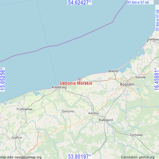
Ustronie Morskie GPS coordinates[2]
54° 12' 54.612" North, 15° 45' 20.448" East
| Map corner | latitude | longitude |
|---|---|---|
| Upper-left | 54.62427°, | 15.05256° |
| Center: | 54.21517°, | 15.75568° |
| Lower-right: | 53.80197°, | 16.45881° |
| Map W x H: | 91.4×91.4 km | = 56.8×56.8mi |
| max Lat: | 54.83135° ⇑3.5% North |
| Ustronie Morskie: | 54.21517° |
| min Lat: | ⇓96.5% South 49.21328° |
| min Long | Ustronie Morski | max Long |
| 14.20249° | 15.75568° | 24.03723° |
| W 6.1%⇐ | ⇒93.9% E |
Elevation
Elevation of Ustronie Morskie is 7 m = 23 ft, and this is 184.4 m = 605 ft below average elevation for this country.
| Max E: |
974 m = 3196 ft | 98.7% |
| Avg. | 191.4 m = 628 ft | |
| Ustronie Morskie | 7 m = 23 ft | |
Min E: |
-3 m = -10 ft | 1.3% |
See also: Poland elevation on elevation.city.
Geographical zone
Ustronie Morskie is located in North temperate zone (between Tropic of Cancer and the Arctic Circle). Distance of this North polar circle is 1373 km =853.1 mi to North.| Distance of | km | miles | from Ustronie Morskie |
|---|---|---|---|
| North Pole | 3978.9 | 2472.4 | to North |
| Arctic Circle | 1373 | 853.1 | to North |
| Tropic Cancer | 3422.2 | 2126.5 | to South |
| Equator | 6028.2 | 3745.7 | to South |


Nearby cities:
15 places around Ustronie Morskie: (largest is in red/bold)
• Białogard
27.6 km =17.1 mi,  146°
146°
• Biesiekierz
20.6 km =12.8 mi,  116°
116°
• Będzino
15.3 km =9.5 mi,  92°
92°
• Drzonowo
24.6 km =15.3 mi,  237°
237°
• Dygowo
9.7 km =6 mi,  193°
193°
• Dźwirzyno
23.3 km =14.5 mi,  254°
254°
• Gościno
19.4 km =12.1 mi,  200°
200°
• Grzybowo
18.7 km =11.6 mi, 250°
• Jamno
27.1 km =16.8 mi,  82°
82°
• Karlino
21.5 km =13.4 mi,  158°
158°
• Koszalin
27.2 km =16.9 mi, 94°
• Kołobrzeg
12 km =7.5 mi, 248°
• Mielno
20.5 km =12.7 mi, 75°
• Sarbinowo
13.7 km =8.5 mi,  74°
74°
• Siemyśl
25.4 km =15.8 mi,  214°
214°
Sources, notices
• [Note1] Compared only with cities in Poland existing in our database
• [Src1] Map data: © OpenStreetMap contributors (CC-BY-SA)
• [Src2] Other city data from geonames.org with taken over terms of usage.
• [Src3] Geographical zone / Annual Mean Temperature by Robert A. Rohde @ Wikipedia
