Dygowo geodata
Dygowo (West Pomerania) is a populated place; located in Poland in Europe/Warsaw (GMT+2) time zone. With population of 1,549 people, there are 1805 cities with bigger population in this country. Compared to other cities in Poland, 95.6% of cities are located further ↓South; 94.2% of cities are located further →East and 96.4% of cities have higher elevation than Dygowo. Note1


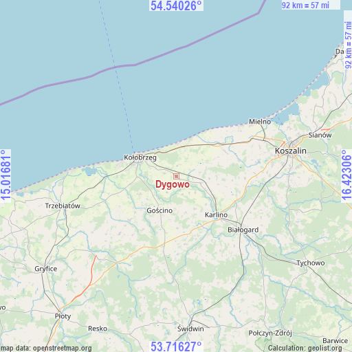
Dygowo GPS coordinates[2]
54° 7' 49.116" North, 15° 43' 11.748" East
| Map corner | latitude | longitude |
|---|---|---|
| Upper-left | 54.54026°, | 15.01681° |
| Center: | 54.13031°, | 15.71993° |
| Lower-right: | 53.71627°, | 16.42306° |
| Map W x H: | 91.6×91.6 km | = 56.9×56.9mi |
| max Lat: | 54.83135° ⇑4.4% North |
| Dygowo: | 54.13031° |
| min Lat: | ⇓95.6% South 49.21328° |
| min Long | Dygowo | max Long |
| 14.20249° | 15.71993° | 24.03723° |
| W 5.8%⇐ | ⇒94.2% E |
Elevation
Elevation of Dygowo is 28 m = 92 ft, and this is 163.4 m = 536 ft below average elevation for this country.
| Max E: |
974 m = 3196 ft | 96.4% |
| Avg. | 191.4 m = 628 ft | |
| Dygowo | 28 m = 92 ft | |
Min E: |
-3 m = -10 ft | 3.6% |
See also: Poland elevation on elevation.city.
Geographical zone
Dygowo is located in North temperate zone (between Tropic of Cancer and the Arctic Circle). Distance of this North polar circle is 1382.4 km =859 mi to North.| Distance of | km | miles | from Dygowo |
|---|---|---|---|
| North Pole | 3988.3 | 2478.2 | to North |
| Arctic Circle | 1382.4 | 859 | to North |
| Tropic Cancer | 3412.8 | 2120.6 | to South |
| Equator | 6018.7 | 3739.8 | to South |


Nearby cities:
15 places around Dygowo: (largest is in red/bold)
• Białogard
22.2 km =13.8 mi,  128°
128°
• Biesiekierz
20.8 km =12.9 mi,  89°
89°
• Będzino
19.7 km =12.2 mi,  63°
63°
• Drzonowo
18.9 km =11.7 mi,  258°
258°
• Dźwirzyno
20.4 km =12.7 mi,  279°
279°
• Gościno
9.8 km =6.1 mi,  206°
206°
• Grzybowo
15.6 km =9.7 mi, 281°
• Karlino
14.7 km =9.1 mi,  135°
135°
• Kołobrzeg
10.2 km =6.3 mi,  299°
299°
• Mielno
26.6 km =16.5 mi, 56°
• Rymań
24.2 km =15 mi, 211°
• Sarbinowo
20.4 km =12.7 mi,  49°
49°
• Siemyśl
16.7 km =10.4 mi,  226°
226°
• Sławoborze
26.7 km =16.6 mi,  181°
181°
• Ustronie Morskie
9.7 km =6 mi,  13°
13°
Sources, notices
• [Note1] Compared only with cities in Poland existing in our database
• [Src1] Map data: © OpenStreetMap contributors (CC-BY-SA)
• [Src2] Other city data from geonames.org with taken over terms of usage.
• [Src3] Geographical zone / Annual Mean Temperature by Robert A. Rohde @ Wikipedia
