Gołkowice geodata
Gołkowice (Silesia) is a populated place; located in Poland in Europe/Warsaw (GMT+2) time zone. With population of 3,582 people, there are 896 cities with bigger population in this country. Compared to other cities in Poland, 86.9% of cities are located further ↑North; 67.8% of cities are located further →East and 73.8% of cities have lower elevation than Gołkowice. Note1


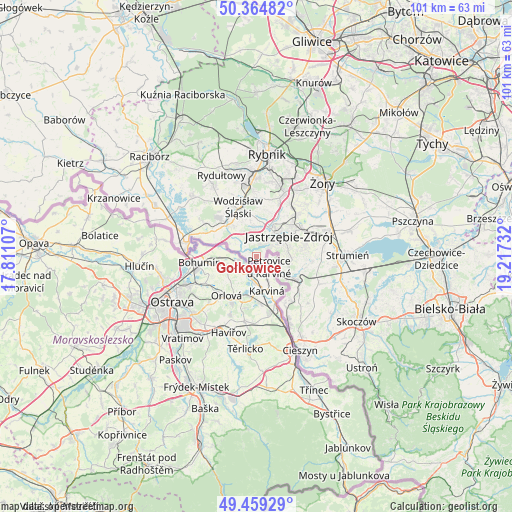
Gołkowice GPS coordinates[2]
49° 54' 51.048" North, 18° 30' 51.084" East
| Map corner | latitude | longitude |
|---|---|---|
| Upper-left | 50.36482°, | 17.81107° |
| Center: | 49.91418°, | 18.51419° |
| Lower-right: | 49.45929°, | 19.21732° |
| Map W x H: | 100.7×100.7 km | = 62.6×62.6mi |
| max Lat: | 54.83135° ⇑86.9% North |
| Gołkowice: | 49.91418° |
| min Lat: | ⇓13.1% South 49.21328° |
| min Long | Gołkowice | max Long |
| 14.20249° | 18.51419° | 24.03723° |
| W 32.2%⇐ | ⇒67.8% E |
Elevation
Elevation of Gołkowice is 242 m = 794 ft, and this is 50.6 m = 166 ft above average elevation for this country.
| Max E: |
974 m = 3196 ft | 26.2% |
| Gołkowice | 242 m 794 ft | |
| Avg. | 191.4 m = 628 ft | |
Min E: |
-3 m = -10 ft | 73.8% |
See also: Poland elevation on elevation.city.
Geographical zone
Gołkowice is located in North temperate zone (between Tropic of Cancer and the Arctic Circle). Distance of this North polar circle is 1851.2 km =1150.3 mi to North.| Distance of | km | miles | from Gołkowice |
|---|---|---|---|
| North Pole | 4457.1 | 2769.5 | to North |
| Arctic Circle | 1851.2 | 1150.3 | to North |
| Tropic Cancer | 2944 | 1829.3 | to South |
| Equator | 5549.9 | 3448.5 | to South |


Nearby cities:
15 places around Gołkowice: (largest is in red/bold)
• Godów
2.8 km =1.7 mi,  294°
294°
• Gogołowa
9.7 km =6 mi,  34°
34°
• Gorzyce
9.7 km =6 mi,  301°
301°
• Gorzyczki
8.8 km =5.5 mi, 296°
• Jastrzębie Zdrój
6.3 km =3.9 mi,  43°
43°
• Kaczyce
11.1 km =6.9 mi,  150°
150°
• Kończyce Małe
10.3 km =6.4 mi,  126°
126°
• Mszana
6.2 km =3.9 mi,  9°
9°
• Pielgrzymowice
9.7 km =6 mi,  95°
95°
• Połomia
9 km =5.6 mi,  16°
16°
• Skrzyszów
4.3 km =2.7 mi,  334°
334°
• Turza Śląska
8.5 km =5.3 mi,  319°
319°
• Wodzisław Śląski
10.4 km =6.5 mi,  343°
343°
• Zebrzydowice
8 km =5 mi,  120°
120°
• Łaziska
5.4 km =3.4 mi, 296°
Sources, notices
• [Note1] Compared only with cities in Poland existing in our database
• [Src1] Map data: © OpenStreetMap contributors (CC-BY-SA)
• [Src2] Other city data from geonames.org with taken over terms of usage.
• [Src3] Geographical zone / Annual Mean Temperature by Robert A. Rohde @ Wikipedia
