Pielgrzymowice geodata
Pielgrzymowice (Silesia) is a populated place; located in Poland in Europe/Warsaw (GMT+2) time zone. With population of 2,407 people, there are 1282 cities with bigger population in this country. Compared to other cities in Poland, 87.3% of cities are located further ↑North; 65.7% of cities are located further →East and 72.4% of cities have lower elevation than Pielgrzymowice. Note1


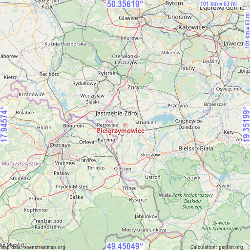
Pielgrzymowice GPS coordinates[2]
49° 54' 19.692" North, 18° 38' 55.896" East
| Map corner | latitude | longitude |
|---|---|---|
| Upper-left | 50.35619°, | 17.94574° |
| Center: | 49.90547°, | 18.64886° |
| Lower-right: | 49.45049°, | 19.35199° |
| Map W x H: | 100.7×100.7 km | = 62.6×62.6mi |
| max Lat: | 54.83135° ⇑87.3% North |
| Pielgrzymowice: | 49.90547° |
| min Lat: | ⇓12.7% South 49.21328° |
| min Long | Pielgrzymowice | max Long |
| 14.20249° | 18.64886° | 24.03723° |
| W 34.3%⇐ | ⇒65.7% E |
Elevation
Elevation of Pielgrzymowice is 237 m = 778 ft, and this is 45.6 m = 150 ft above average elevation for this country.
| Max E: |
974 m = 3196 ft | 27.6% |
| Pielgrzymowice | 237 m 778 ft | |
| Avg. | 191.4 m = 628 ft | |
Min E: |
-3 m = -10 ft | 72.4% |
See also: Poland elevation on elevation.city.
Geographical zone
Pielgrzymowice is located in North temperate zone (between Tropic of Cancer and the Arctic Circle). Distance of this North polar circle is 1852.2 km =1150.9 mi to North.| Distance of | km | miles | from Pielgrzymowice |
|---|---|---|---|
| North Pole | 4458.1 | 2770.1 | to North |
| Arctic Circle | 1852.2 | 1150.9 | to North |
| Tropic Cancer | 2943 | 1828.7 | to South |
| Equator | 5549 | 3448 | to South |


Nearby cities:
15 places around Pielgrzymowice: (largest is in red/bold)
• Bąków
4.9 km =3 mi,  105°
105°
• Drogomyśl
8.7 km =5.4 mi,  117°
117°
• Gogołowa
9.9 km =6.2 mi,  335°
335°
• Gołkowice
9.7 km =6 mi,  275°
275°
• Jastrzębie Zdrój
7.7 km =4.8 mi,  316°
316°
• Kaczyce
9.6 km =6 mi,  205°
205°
• Kończyce Małe
5.4 km =3.4 mi,  194°
194°
• Kończyce Wielkie
7.8 km =4.8 mi,  182°
182°
• Krzyżowice
9 km =5.6 mi,  10°
10°
• Pawłowice
7.9 km =4.9 mi,  38°
38°
• Pruchna
5.1 km =3.2 mi,  152°
152°
• Strumień
8.6 km =5.3 mi,  78°
78°
• Zabłocie
9.5 km =5.9 mi,  91°
91°
• Zbytków
5.9 km =3.7 mi,  70°
70°
• Zebrzydowice
4.1 km =2.5 mi,  221°
221°
Sources, notices
• [Note1] Compared only with cities in Poland existing in our database
• [Src1] Map data: © OpenStreetMap contributors (CC-BY-SA)
• [Src2] Other city data from geonames.org with taken over terms of usage.
• [Src3] Geographical zone / Annual Mean Temperature by Robert A. Rohde @ Wikipedia
