Gogołowa geodata
Gogołowa (Silesia) is a populated place; located in Poland in Europe/Warsaw (GMT+2) time zone. With population of 989 people, there are 2521 cities with bigger population in this country. Compared to other cities in Poland, 83.3% of cities are located further ↑North; 66.9% of cities are located further →East and 77.6% of cities have lower elevation than Gogołowa. Note1


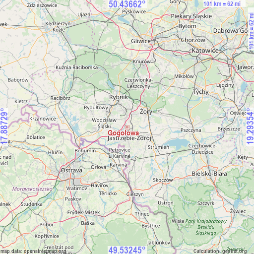
Gogołowa GPS coordinates[2]
49° 59' 11.976" North, 18° 35' 25.476" East
| Map corner | latitude | longitude |
|---|---|---|
| Upper-left | 50.43662°, | 17.88729° |
| Center: | 49.98666°, | 18.59041° |
| Lower-right: | 49.53245°, | 19.29354° |
| Map W x H: | 100.5×100.5 km | = 62.4×62.4mi |
| max Lat: | 54.83135° ⇑83.3% North |
| Gogołowa: | 49.98666° |
| min Lat: | ⇓16.7% South 49.21328° |
| min Long | Gogołowa | max Long |
| 14.20249° | 18.59041° | 24.03723° |
| W 33.1%⇐ | ⇒66.9% E |
Elevation
Elevation of Gogołowa is 256 m = 840 ft, and this is 64.6 m = 212 ft above average elevation for this country.
| Max E: |
974 m = 3196 ft | 22.4% |
| Gogołowa | 256 m 840 ft | |
| Avg. | 191.4 m = 628 ft | |
Min E: |
-3 m = -10 ft | 77.6% |
See also: Poland elevation on elevation.city.
Geographical zone
Gogołowa is located in North temperate zone (between Tropic of Cancer and the Arctic Circle). Distance of this North polar circle is 1843.2 km =1145.3 mi to North.| Distance of | km | miles | from Gogołowa |
|---|---|---|---|
| North Pole | 4449.1 | 2764.5 | to North |
| Arctic Circle | 1843.2 | 1145.3 | to North |
| Tropic Cancer | 2952.1 | 1834.3 | to South |
| Equator | 5558 | 3453.6 | to South |


Nearby cities:
15 places around Gogołowa: (largest is in red/bold)
• Godów
10.6 km =6.6 mi,  229°
229°
• Gołkowice
9.7 km =6 mi,  214°
214°
• Jankowice Rybnickie
7.2 km =4.5 mi,  334°
334°
• Jastrzębie Zdrój
3.6 km =2.2 mi,  197°
197°
• Krzyżowice
5.9 km =3.7 mi,  91°
91°
• Markłowice
6 km =3.7 mi,  304°
304°
• Mszana
4.9 km =3 mi,  246°
246°
• Pawłowice
9.5 km =5.9 mi,  107°
107°
• Pielgrzymowice
9.9 km =6.2 mi,  155°
155°
• Połomia
2.9 km =1.8 mi,  281°
281°
• Skrzyszów
8.4 km =5.2 mi,  239°
239°
• Wodzisław Śląski
8.7 km =5.4 mi, 282°
• Świerklany Dolne
3.6 km =2.2 mi,  344°
344°
• Świerklany Górne
4.6 km =2.9 mi,  0°
0°
• Żory
10.2 km =6.3 mi,  50°
50°
Sources, notices
• [Note1] Compared only with cities in Poland existing in our database
• [Src1] Map data: © OpenStreetMap contributors (CC-BY-SA)
• [Src2] Other city data from geonames.org with taken over terms of usage.
• [Src3] Geographical zone / Annual Mean Temperature by Robert A. Rohde @ Wikipedia
