Gniewkowo geodata
Gniewkowo (Kujawsko-Pomorskie) is a seat of a third-order administrative division; located in Poland in Europe/Warsaw (GMT+2) time zone. With population of 7,224 people, there are 526 cities with bigger population in this country. Compared to other cities in Poland, 82.3% of cities are located further ↓South; 69.5% of cities are located further →East and 88.9% of cities have higher elevation than Gniewkowo. Note1
Administrative division(s):
- Level 1: Kujawsko-Pomorskie
- Level 2: Powiat inowrocławski
- Level 3: Gniewkowo


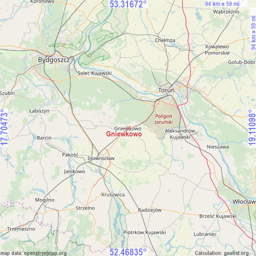
Gniewkowo GPS coordinates[2]
52° 53' 40.596" North, 18° 24' 28.26" East
| Map corner | latitude | longitude |
|---|---|---|
| Upper-left | 53.31672°, | 17.70473° |
| Center: | 52.89461°, | 18.40785° |
| Lower-right: | 52.46835°, | 19.11098° |
| Map W x H: | 94.3×94.3 km | = 58.6×58.6mi |
| max Lat: | 54.83135° ⇑17.7% North |
| Gniewkowo: | 52.89461° |
| min Lat: | ⇓82.3% South 49.21328° |
| min Long | Gniewkowo | max Long |
| 14.20249° | 18.40785° | 24.03723° |
| W 30.5%⇐ | ⇒69.5% E |
Elevation
Elevation of Gniewkowo is 79 m = 259 ft, and this is 112.4 m = 369 ft below average elevation for this country.
| Max E: |
974 m = 3196 ft | 88.9% |
| Avg. | 191.4 m = 628 ft | |
| Gniewkowo | 79 m = 259 ft | |
Min E: |
-3 m = -10 ft | 11.1% |
See also: Poland elevation on elevation.city.
Geographical zone
Gniewkowo is located in North temperate zone (between Tropic of Cancer and the Arctic Circle). Distance of this North polar circle is 1519.8 km =944.4 mi to North.| Distance of | km | miles | from Gniewkowo |
|---|---|---|---|
| North Pole | 4125.7 | 2563.6 | to North |
| Arctic Circle | 1519.8 | 944.4 | to North |
| Tropic Cancer | 3275.4 | 2035.2 | to South |
| Equator | 5881.3 | 3654.5 | to South |


Nearby cities:
15 places around Gniewkowo: (largest is in red/bold)
• Aleksandrów Kujawski
19.3 km =12 mi,  95°
95°
• Dąbrowa Biskupia
15.8 km =9.8 mi,  144°
144°
• Inowrocław
14.4 km =8.9 mi,  222°
222°
• Koneck
24.3 km =15.1 mi,  120°
120°
• Kościelec
20.2 km =12.6 mi,  236°
236°
• Nowa Wieś Wielka
22.9 km =14.2 mi,  291°
291°
• Pakość
24 km =14.9 mi, 244°
• Rojewo
8.8 km =5.5 mi,  275°
275°
• Toporzysko
24.1 km =15 mi,  341°
341°
• Toruń
18.4 km =11.4 mi,  43°
43°
• Wielka Nieszawka
13.2 km =8.2 mi,  31°
31°
• Wierzchosławice
4.5 km =2.8 mi,  230°
230°
• Zakrzewo
21.3 km =13.2 mi, 135°
• Zławieś Wielka
23 km =14.3 mi,  346°
346°
• Złotniki Kujawskie
17.6 km =10.9 mi,  271°
271°
Sources, notices
• [Note1] Compared only with cities in Poland existing in our database
• [Src1] Map data: © OpenStreetMap contributors (CC-BY-SA)
• [Src2] Other city data from geonames.org with taken over terms of usage.
• [Src3] Geographical zone / Annual Mean Temperature by Robert A. Rohde @ Wikipedia
