Wielka Nieszawka geodata
Wielka Nieszawka (Kujawsko-Pomorskie) is a seat of a third-order administrative division; located in Poland in Europe/Warsaw (GMT+2) time zone. With population of 460 people, there are 3556 cities with bigger population in this country. Compared to other cities in Poland, 83.6% of cities are located further ↓South; 67.9% of cities are located further →East and 95.4% of cities have higher elevation than Wielka Nieszawka. Note1
Administrative division(s):
- Level 1: Kujawsko-Pomorskie
- Level 2: Powiat toruński
- Level 3: Wielka Nieszawka


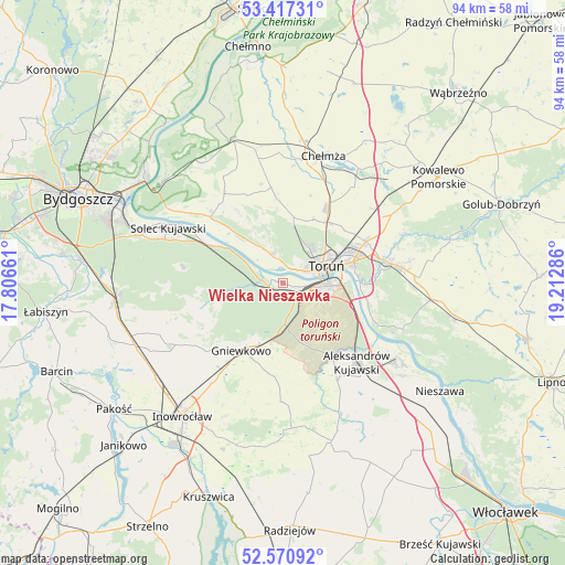
Wielka Nieszawka GPS coordinates[2]
52° 59' 46.284" North, 18° 30' 35.028" East
| Map corner | latitude | longitude |
|---|---|---|
| Upper-left | 53.41731°, | 17.80661° |
| Center: | 52.99619°, | 18.50973° |
| Lower-right: | 52.57092°, | 19.21286° |
| Map W x H: | 94.1×94.1 km | = 58.5×58.5mi |
| max Lat: | 54.83135° ⇑16.4% North |
| Wielka Nieszawka: | 52.99619° |
| min Lat: | ⇓83.6% South 49.21328° |
| min Long | Wielka Nieszawk | max Long |
| 14.20249° | 18.50973° | 24.03723° |
| W 32.1%⇐ | ⇒67.9% E |
Elevation
Elevation of Wielka Nieszawka is 37 m = 121 ft, and this is 154.4 m = 507 ft below average elevation for this country.
| Max E: |
974 m = 3196 ft | 95.4% |
| Avg. | 191.4 m = 628 ft | |
| Wielka Nieszawka | 37 m = 121 ft | |
Min E: |
-3 m = -10 ft | 4.6% |
See also: Poland elevation on elevation.city.
Geographical zone
Wielka Nieszawka is located in North temperate zone (between Tropic of Cancer and the Arctic Circle). Distance of this North polar circle is 1508.6 km =937.4 mi to North.| Distance of | km | miles | from Wielka Nieszawka |
|---|---|---|---|
| North Pole | 4114.4 | 2556.6 | to North |
| Arctic Circle | 1508.6 | 937.4 | to North |
| Tropic Cancer | 3286.7 | 2042.3 | to South |
| Equator | 5892.6 | 3661.5 | to South |


Nearby cities:
15 places around Wielka Nieszawka: (largest is in red/bold)
• Aleksandrów Kujawski
18.1 km =11.2 mi,  137°
137°
• Chełmża
21.9 km =13.6 mi,  16°
16°
• Ciechocinek
23.1 km =14.4 mi,  124°
124°
• Gniewkowo
13.2 km =8.2 mi,  211°
211°
• Lubicz Dolny
16.3 km =10.1 mi,  76°
76°
• Lubicz Górny
17.8 km =11.1 mi, 78°
• Osiek
21.4 km =13.3 mi,  111°
111°
• Rojewo
18.8 km =11.7 mi,  236°
236°
• Solec Kujawski
21.3 km =13.2 mi,  297°
297°
• Toporzysko
18.5 km =11.5 mi,  308°
308°
• Toruń
6.2 km =3.9 mi,  71°
71°
• Wierzchosławice
17.5 km =10.9 mi,  216°
216°
• Zławieś Wielka
16.4 km =10.2 mi, 312°
• Łubianka
16 km =9.9 mi,  353°
353°
• Łysomice
12.4 km =7.7 mi,  36°
36°
Sources, notices
• [Note1] Compared only with cities in Poland existing in our database
• [Src1] Map data: © OpenStreetMap contributors (CC-BY-SA)
• [Src2] Other city data from geonames.org with taken over terms of usage.
• [Src3] Geographical zone / Annual Mean Temperature by Robert A. Rohde @ Wikipedia
