Głuchołazy geodata
Głuchołazy (Opole Voivodeship) is a seat of a third-order administrative division; located in Poland in Europe/Warsaw (GMT+2) time zone. With population of 15,120 people, there are 330 cities with bigger population in this country. Compared to other cities in Poland, 71.7% of cities are located further ↑North; 80.8% of cities are located further →East and 84.7% of cities have lower elevation than Głuchołazy. Note1


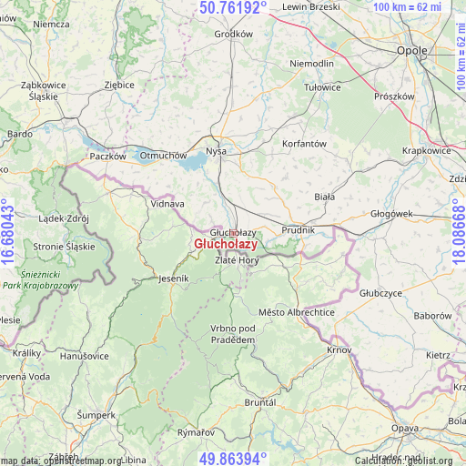
Głuchołazy GPS coordinates[2]
50° 18' 54.18" North, 17° 23' 0.78" East
| Map corner | latitude | longitude |
|---|---|---|
| Upper-left | 50.76192°, | 16.68043° |
| Center: | 50.31505°, | 17.38355° |
| Lower-right: | 49.86394°, | 18.08668° |
| Map W x H: | 99.8×99.8 km | = 62×62mi |
| max Lat: | 54.83135° ⇑71.7% North |
| Głuchołazy: | 50.31505° |
| min Lat: | ⇓28.3% South 49.21328° |
| min Long | Głuchołazy | max Long |
| 14.20249° | 17.38355° | 24.03723° |
| W 19.2%⇐ | ⇒80.8% E |
Elevation
Elevation of Głuchołazy is 288 m = 945 ft, and this is 96.6 m = 317 ft above average elevation for this country.
| Max E: |
974 m = 3196 ft | 15.3% |
| Głuchołazy | 288 m 945 ft | |
| Avg. | 191.4 m = 628 ft | |
Min E: |
-3 m = -10 ft | 84.7% |
See also: Poland elevation on elevation.city.
Geographical zone
Głuchołazy is located in North temperate zone (between Tropic of Cancer and the Arctic Circle). Distance of this North polar circle is 1806.7 km =1122.6 mi to North.| Distance of | km | miles | from Głuchołazy |
|---|---|---|---|
| North Pole | 4412.6 | 2741.9 | to North |
| Arctic Circle | 1806.7 | 1122.6 | to North |
| Tropic Cancer | 2988.6 | 1857 | to South |
| Equator | 5594.5 | 3476.3 | to South |


Nearby cities:
15 places around Głuchołazy: (largest is in red/bold)
• Biała
21.2 km =13.2 mi,  68°
68°
• Jasienica Dolna
23.9 km =14.9 mi,  20°
20°
• Korfantów
24.6 km =15.3 mi,  38°
38°
• Lubrza
17.4 km =10.8 mi,  82°
82°
• Maciejowice
27.1 km =16.8 mi,  319°
319°
• Moszczanka
7.8 km =4.8 mi,  102°
102°
• Nysa
18 km =11.2 mi,  348°
348°
• Otmuchów
22.5 km =14 mi, 318°
• Pakosławice
25.6 km =15.9 mi,  357°
357°
• Prudnik
13.6 km =8.5 mi,  87°
87°
• Prusinowice
24.7 km =15.3 mi,  3°
3°
• Racławice Śląskie
27.8 km =17.3 mi, 90°
• Sidzina
29.1 km =18.1 mi,  9°
9°
• Łambinowice
27.9 km =17.3 mi,  26°
26°
• Łąka Prudnicka
10.3 km =6.4 mi, 92°
Sources, notices
• [Note1] Compared only with cities in Poland existing in our database
• [Src1] Map data: © OpenStreetMap contributors (CC-BY-SA)
• [Src2] Other city data from geonames.org with taken over terms of usage.
• [Src3] Geographical zone / Annual Mean Temperature by Robert A. Rohde @ Wikipedia
