Lubrza geodata
Lubrza (Opole Voivodeship) is a seat of a third-order administrative division; located in Poland in Europe/Warsaw (GMT+2) time zone. With population of 988 people, there are 2523 cities with bigger population in this country. Compared to other cities in Poland, 71.2% of cities are located further ↑North; 78.9% of cities are located further →East and 75.5% of cities have lower elevation than Lubrza. Note1


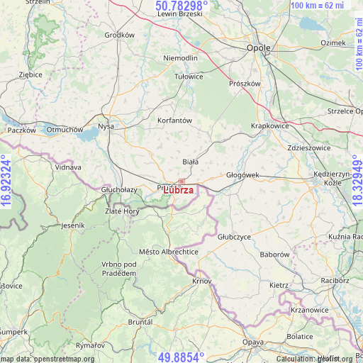
Lubrza GPS coordinates[2]
50° 20' 10.716" North, 17° 37' 34.896" East
| Map corner | latitude | longitude |
|---|---|---|
| Upper-left | 50.78298°, | 16.92324° |
| Center: | 50.33631°, | 17.62636° |
| Lower-right: | 49.8854°, | 18.32949° |
| Map W x H: | 99.8×99.8 km | = 62×62mi |
| max Lat: | 54.83135° ⇑71.2% North |
| Lubrza: | 50.33631° |
| min Lat: | ⇓28.8% South 49.21328° |
| min Long | Lubrza | max Long |
| 14.20249° | 17.62636° | 24.03723° |
| W 21.1%⇐ | ⇒78.9% E |
Elevation
Elevation of Lubrza is 248 m = 814 ft, and this is 56.6 m = 186 ft above average elevation for this country.
| Max E: |
974 m = 3196 ft | 24.5% |
| Lubrza | 248 m 814 ft | |
| Avg. | 191.4 m = 628 ft | |
Min E: |
-3 m = -10 ft | 75.5% |
See also: Poland elevation on elevation.city.
Geographical zone
Lubrza is located in North temperate zone (between Tropic of Cancer and the Arctic Circle). Distance of this North polar circle is 1804.3 km =1121.1 mi to North.| Distance of | km | miles | from Lubrza |
|---|---|---|---|
| North Pole | 4410.2 | 2740.4 | to North |
| Arctic Circle | 1804.3 | 1121.1 | to North |
| Tropic Cancer | 2991 | 1858.5 | to South |
| Equator | 5596.9 | 3477.8 | to South |


Nearby cities:
15 places around Lubrza: (largest is in red/bold)
• Biała
6 km =3.7 mi,  23°
23°
• Głogówek
17 km =10.6 mi,  83°
83°
• Głubczyce
20.8 km =12.9 mi,  136°
136°
• Głuchołazy
17.4 km =10.8 mi,  262°
262°
• Jasienica Dolna
22 km =13.7 mi,  335°
335°
• Korfantów
17.1 km =10.6 mi,  353°
353°
• Kujawy
17.5 km =10.9 mi,  47°
47°
• Kórnica
21.2 km =13.2 mi,  69°
69°
• Moszczanka
10.4 km =6.5 mi,  247°
247°
• Prudnik
4 km =2.5 mi, 245°
• Racławice Śląskie
10.9 km =6.8 mi,  104°
104°
• Rozkochów
22.6 km =14 mi, 80°
• Strzeleczki
21.5 km =13.4 mi, 49°
• Łambinowice
23 km =14.3 mi, 348°
• Łąka Prudnicka
7.5 km =4.7 mi, 247°
Sources, notices
• [Note1] Compared only with cities in Poland existing in our database
• [Src1] Map data: © OpenStreetMap contributors (CC-BY-SA)
• [Src2] Other city data from geonames.org with taken over terms of usage.
• [Src3] Geographical zone / Annual Mean Temperature by Robert A. Rohde @ Wikipedia
