Prusinowice geodata
Prusinowice (Opole Voivodeship) is a populated place; located in Poland in Europe/Warsaw (GMT+2) time zone. With population of 743 people, there are 2989 cities with bigger population in this country. Compared to other cities in Poland, 66.6% of cities are located further ↑North; 80.6% of cities are located further →East and 53% of cities have lower elevation than Prusinowice. Note1


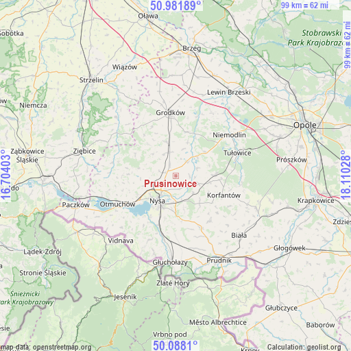
Prusinowice GPS coordinates[2]
50° 32' 13.596" North, 17° 24' 25.74" East
| Map corner | latitude | longitude |
|---|---|---|
| Upper-left | 50.98189°, | 16.70403° |
| Center: | 50.53711°, | 17.40715° |
| Lower-right: | 50.0881°, | 18.11028° |
| Map W x H: | 99.4×99.4 km | = 61.8×61.8mi |
| max Lat: | 54.83135° ⇑66.6% North |
| Prusinowice: | 50.53711° |
| min Lat: | ⇓33.4% South 49.21328° |
| min Long | Prusinowice | max Long |
| 14.20249° | 17.40715° | 24.03723° |
| W 19.4%⇐ | ⇒80.6% E |
Elevation
Elevation of Prusinowice is 180 m = 591 ft, and this is 11.4 m = 37 ft below average elevation for this country.
| Max E: |
974 m = 3196 ft | 47% |
| Avg. | 191.4 m = 628 ft | |
| Prusinowice | 180 m = 591 ft | |
Min E: |
-3 m = -10 ft | 53% |
See also: Poland elevation on elevation.city.
Geographical zone
Prusinowice is located in North temperate zone (between Tropic of Cancer and the Arctic Circle). Distance of this North polar circle is 1782 km =1107.3 mi to North.| Distance of | km | miles | from Prusinowice |
|---|---|---|---|
| North Pole | 4387.9 | 2726.5 | to North |
| Arctic Circle | 1782 | 1107.3 | to North |
| Tropic Cancer | 3013.3 | 1872.4 | to South |
| Equator | 5619.2 | 3491.6 | to South |


Nearby cities:
15 places around Prusinowice: (largest is in red/bold)
• Chróścina
9.9 km =6.2 mi,  344°
344°
• Grodków
18 km =11.2 mi,  354°
354°
• Jasienica Dolna
6.9 km =4.3 mi,  108°
108°
• Kamiennik
18.6 km =11.6 mi,  281°
281°
• Korfantów
14.6 km =9.1 mi, 111°
• Maciejowice
19.4 km =12.1 mi,  258°
258°
• Niemodlin
19 km =11.8 mi,  52°
52°
• Nysa
8.7 km =5.4 mi,  216°
216°
• Otmuchów
18.3 km =11.4 mi,  244°
244°
• Pakosławice
3 km =1.9 mi,  286°
286°
• Przeworno
23.8 km =14.8 mi,  314°
314°
• Sidzina
5 km =3.1 mi,  35°
35°
• Skoroszyce
6.8 km =4.2 mi, 345°
• Tułowice
18.6 km =11.6 mi,  69°
69°
• Łambinowice
10.9 km =6.8 mi,  89°
89°
Sources, notices
• [Note1] Compared only with cities in Poland existing in our database
• [Src1] Map data: © OpenStreetMap contributors (CC-BY-SA)
• [Src2] Other city data from geonames.org with taken over terms of usage.
• [Src3] Geographical zone / Annual Mean Temperature by Robert A. Rohde @ Wikipedia
