Racławice Śląskie geodata
Racławice Śląskie (Opole Voivodeship) is a populated place; located in Poland in Europe/Warsaw (GMT+2) time zone. With population of 1,600 people, there are 1751 cities with bigger population in this country. Compared to other cities in Poland, 71.8% of cities are located further ↑North; 77.5% of cities are located further →East and 61.9% of cities have lower elevation than Racławice Śląskie. Note1


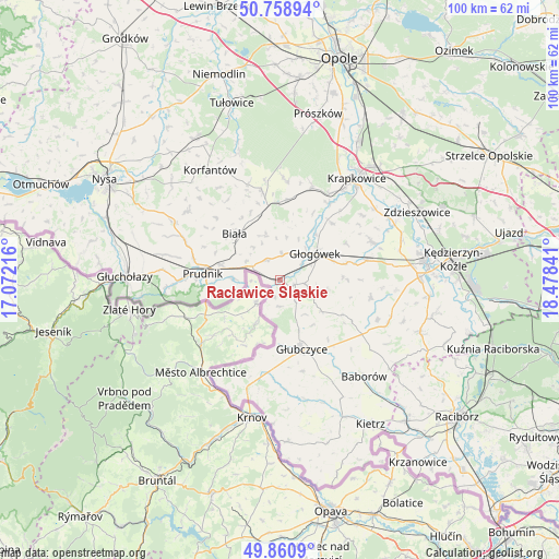
Racławice Śląskie GPS coordinates[2]
50° 18' 43.344" North, 17° 46' 31.008" East
| Map corner | latitude | longitude |
|---|---|---|
| Upper-left | 50.75894°, | 17.07216° |
| Center: | 50.31204°, | 17.77528° |
| Lower-right: | 49.8609°, | 18.47841° |
| Map W x H: | 99.9×99.9 km | = 62.1×62.1mi |
| max Lat: | 54.83135° ⇑71.8% North |
| Racławice Śląskie: | 50.31204° |
| min Lat: | ⇓28.2% South 49.21328° |
| min Long | Racławice Śl� | max Long |
| 14.20249° | 17.77528° | 24.03723° |
| W 22.5%⇐ | ⇒77.5% E |
Elevation
Elevation of Racławice Śląskie is 205 m = 673 ft, and this is 13.6 m = 45 ft above average elevation for this country.
| Max E: |
974 m = 3196 ft | 38.1% |
| Racławice Śląskie | 205 m 673 ft | |
| Avg. | 191.4 m = 628 ft | |
Min E: |
-3 m = -10 ft | 61.9% |
See also: Poland elevation on elevation.city.
Geographical zone
Racławice Śląskie is located in North temperate zone (between Tropic of Cancer and the Arctic Circle). Distance of this North polar circle is 1807 km =1122.8 mi to North.| Distance of | km | miles | from Racławice Śląskie |
|---|---|---|---|
| North Pole | 4412.9 | 2742 | to North |
| Arctic Circle | 1807 | 1122.8 | to North |
| Tropic Cancer | 2988.3 | 1856.8 | to South |
| Equator | 5594.2 | 3476.1 | to South |


Nearby cities:
15 places around Racławice Śląskie: (largest is in red/bold)
• Biała
11.6 km =7.2 mi,  315°
315°
• Dobieszowice
18.7 km =11.6 mi,  72°
72°
• Dobra
18.1 km =11.2 mi,  31°
31°
• Głogówek
7.8 km =4.8 mi,  53°
53°
• Głubczyce
12.9 km =8 mi,  162°
162°
• Kujawy
14.8 km =9.2 mi,  8°
8°
• Kórnica
13.8 km =8.6 mi,  42°
42°
• Lubrza
10.9 km =6.8 mi,  284°
284°
• Moszczanka
20.2 km =12.6 mi,  266°
266°
• Prudnik
14.3 km =8.9 mi, 274°
• Rozkochów
13.4 km =8.3 mi,  60°
60°
• Strzeleczki
17.7 km =11 mi,  19°
19°
• Twardawa
15.7 km =9.8 mi,  77°
77°
• Walce
17.6 km =10.9 mi, 67°
• Łąka Prudnicka
17.6 km =10.9 mi, 269°
Sources, notices
• [Note1] Compared only with cities in Poland existing in our database
• [Src1] Map data: © OpenStreetMap contributors (CC-BY-SA)
• [Src2] Other city data from geonames.org with taken over terms of usage.
• [Src3] Geographical zone / Annual Mean Temperature by Robert A. Rohde @ Wikipedia
