Biała geodata
Biała (Opole Voivodeship) is a seat of a third-order administrative division; located in Poland in Europe/Warsaw (GMT+2) time zone. With population of 2,605 people, there are 1200 cities with bigger population in this country. Compared to other cities in Poland, 69.7% of cities are located further ↑North; 78.7% of cities are located further →East and 71.6% of cities have lower elevation than Biała. Note1


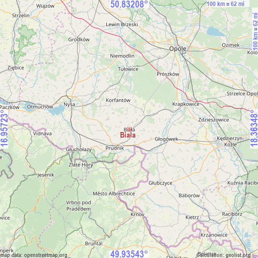
Biała GPS coordinates[2]
50° 23' 9.132" North, 17° 39' 37.26" East
| Map corner | latitude | longitude |
|---|---|---|
| Upper-left | 50.83208°, | 16.95723° |
| Center: | 50.38587°, | 17.66035° |
| Lower-right: | 49.93543°, | 18.36348° |
| Map W x H: | 99.7×99.7 km | = 62×62mi |
| max Lat: | 54.83135° ⇑69.7% North |
| Biała: | 50.38587° |
| min Lat: | ⇓30.3% South 49.21328° |
| min Long | Biała | max Long |
| 14.20249° | 17.66035° | 24.03723° |
| W 21.3%⇐ | ⇒78.7% E |
Elevation
Elevation of Biała is 234 m = 768 ft, and this is 42.6 m = 140 ft above average elevation for this country.
| Max E: |
974 m = 3196 ft | 28.4% |
| Biała | 234 m 768 ft | |
| Avg. | 191.4 m = 628 ft | |
Min E: |
-3 m = -10 ft | 71.6% |
See also: Poland elevation on elevation.city.
Geographical zone
Biała is located in North temperate zone (between Tropic of Cancer and the Arctic Circle). Distance of this North polar circle is 1798.8 km =1117.7 mi to North.| Distance of | km | miles | from Biała |
|---|---|---|---|
| North Pole | 4404.7 | 2737 | to North |
| Arctic Circle | 1798.8 | 1117.7 | to North |
| Tropic Cancer | 2996.5 | 1861.9 | to South |
| Equator | 5602.4 | 3481.2 | to South |


Nearby cities:
15 places around Biała: (largest is in red/bold)
• Dobra
19 km =11.8 mi,  67°
67°
• Głogówek
14.9 km =9.3 mi,  103°
103°
• Głuchołazy
21.2 km =13.2 mi,  248°
248°
• Jasienica Dolna
18.5 km =11.5 mi,  322°
322°
• Korfantów
12.3 km =7.6 mi,  339°
339°
• Kujawy
12.2 km =7.6 mi,  58°
58°
• Kórnica
17.5 km =10.9 mi,  83°
83°
• Lubrza
6 km =3.7 mi,  203°
203°
• Moszczanka
15.3 km =9.5 mi,  231°
231°
• Prudnik
9.4 km =5.8 mi,  220°
220°
• Racławice Śląskie
11.6 km =7.2 mi,  135°
135°
• Rozkochów
19.9 km =12.4 mi,  94°
94°
• Strzeleczki
16.3 km =10.1 mi, 58°
• Łambinowice
18.4 km =11.4 mi, 337°
• Łąka Prudnicka
12.6 km =7.8 mi, 228°
Sources, notices
• [Note1] Compared only with cities in Poland existing in our database
• [Src1] Map data: © OpenStreetMap contributors (CC-BY-SA)
• [Src2] Other city data from geonames.org with taken over terms of usage.
• [Src3] Geographical zone / Annual Mean Temperature by Robert A. Rohde @ Wikipedia
