Moszczanka geodata
Moszczanka (Opole Voivodeship) is a populated place; located in Poland in Europe/Warsaw (GMT+2) time zone. With population of 1,116 people, there are 2286 cities with bigger population in this country. Compared to other cities in Poland, 72% of cities are located further ↑North; 79.9% of cities are located further →East and 87.1% of cities have lower elevation than Moszczanka. Note1


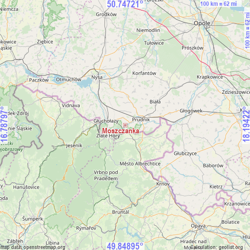
Moszczanka GPS coordinates[2]
50° 18' 0.72" North, 17° 29' 27.924" East
| Map corner | latitude | longitude |
|---|---|---|
| Upper-left | 50.74721°, | 16.78797° |
| Center: | 50.3002°, | 17.49109° |
| Lower-right: | 49.84895°, | 18.19422° |
| Map W x H: | 99.9×99.9 km | = 62.1×62.1mi |
| max Lat: | 54.83135° ⇑72% North |
| Moszczanka: | 50.3002° |
| min Lat: | ⇓28% South 49.21328° |
| min Long | Moszczanka | max Long |
| 14.20249° | 17.49109° | 24.03723° |
| W 20.1%⇐ | ⇒79.9% E |
Elevation
Elevation of Moszczanka is 301 m = 988 ft, and this is 109.6 m = 360 ft above average elevation for this country.
| Max E: |
974 m = 3196 ft | 12.9% |
| Moszczanka | 301 m 988 ft | |
| Avg. | 191.4 m = 628 ft | |
Min E: |
-3 m = -10 ft | 87.1% |
See also: Poland elevation on elevation.city.
Geographical zone
Moszczanka is located in North temperate zone (between Tropic of Cancer and the Arctic Circle). Distance of this North polar circle is 1808.3 km =1123.6 mi to North.| Distance of | km | miles | from Moszczanka |
|---|---|---|---|
| North Pole | 4414.2 | 2742.9 | to North |
| Arctic Circle | 1808.3 | 1123.6 | to North |
| Tropic Cancer | 2986.9 | 1856 | to South |
| Equator | 5592.9 | 3475.3 | to South |


Nearby cities:
15 places around Moszczanka: (largest is in red/bold)
• Biała
15.3 km =9.5 mi,  51°
51°
• Głogówek
27.1 km =16.8 mi,  77°
77°
• Głubczyce
26.4 km =16.4 mi,  114°
114°
• Głuchołazy
7.8 km =4.8 mi,  282°
282°
• Jasienica Dolna
24.1 km =15 mi,  1°
1°
• Korfantów
22.3 km =13.9 mi,  20°
20°
• Kujawy
27.5 km =17.1 mi, 54°
• Lubrza
10.4 km =6.5 mi,  67°
67°
• Nysa
22.3 km =13.9 mi,  330°
330°
• Pakosławice
28.6 km =17.8 mi,  341°
341°
• Prudnik
6.4 km =4 mi, 68°
• Prusinowice
27 km =16.8 mi,  347°
347°
• Racławice Śląskie
20.2 km =12.6 mi,  86°
86°
• Łambinowice
27 km =16.8 mi,  10°
10°
• Łąka Prudnicka
2.9 km =1.8 mi, 66°
Sources, notices
• [Note1] Compared only with cities in Poland existing in our database
• [Src1] Map data: © OpenStreetMap contributors (CC-BY-SA)
• [Src2] Other city data from geonames.org with taken over terms of usage.
• [Src3] Geographical zone / Annual Mean Temperature by Robert A. Rohde @ Wikipedia
