Rychliki geodata
Rychliki (Warmia-Masuria) is a populated place; located in Poland in Europe/Warsaw (GMT+2) time zone. With population of 805 people, there are 2846 cities with bigger population in this country. Compared to other cities in Poland, 94% of cities are located further ↓South; 50.6% of cities are located further →East and 91.3% of cities have higher elevation than Rychliki. Note1


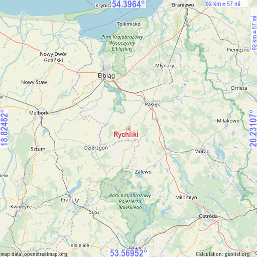
Rychliki GPS coordinates[2]
53° 59' 6.036" North, 19° 31' 40.584" East
| Map corner | latitude | longitude |
|---|---|---|
| Upper-left | 54.3964°, | 18.82482° |
| Center: | 53.98501°, | 19.52794° |
| Lower-right: | 53.56952°, | 20.23107° |
| Map W x H: | 91.9×91.9 km | = 57.1×57.1mi |
| max Lat: | 54.83135° ⇑6% North |
| Rychliki: | 53.98501° |
| min Lat: | ⇓94% South 49.21328° |
| min Long | Rychliki | max Long |
| 14.20249° | 19.52794° | 24.03723° |
| W 49.4%⇐ | ⇒50.6% E |
Elevation
Elevation of Rychliki is 69 m = 226 ft, and this is 122.4 m = 402 ft below average elevation for this country.
| Max E: |
974 m = 3196 ft | 91.3% |
| Avg. | 191.4 m = 628 ft | |
| Rychliki | 69 m = 226 ft | |
Min E: |
-3 m = -10 ft | 8.7% |
See also: Poland elevation on elevation.city.
Geographical zone
Rychliki is located in North temperate zone (between Tropic of Cancer and the Arctic Circle). Distance of this North polar circle is 1398.6 km =869 mi to North.| Distance of | km | miles | from Rychliki |
|---|---|---|---|
| North Pole | 4004.5 | 2488.3 | to North |
| Arctic Circle | 1398.6 | 869 | to North |
| Tropic Cancer | 3396.7 | 2110.6 | to South |
| Equator | 6002.6 | 3729.8 | to South |


Nearby cities:
15 places around Rychliki: (largest is in red/bold)
• Dzierzgoń
13.8 km =8.6 mi,  239°
239°
• Elbląg
20.1 km =12.5 mi,  337°
337°
• Gronowo Elbląskie
18.3 km =11.4 mi,  307°
307°
• Gronowo Górne
17.6 km =10.9 mi,  345°
345°
• Kamiennik Wielki
22.3 km =13.9 mi,  2°
2°
• Markusy
11.1 km =6.9 mi, 310°
• Małdyty
15.9 km =9.9 mi,  117°
117°
• Mikołajki Pomorskie
28 km =17.4 mi, 237°
• Miłomłyn
31.8 km =19.8 mi,  140°
140°
• Morąg
27.1 km =16.8 mi,  106°
106°
• Młynary
25.8 km =16 mi,  29°
29°
• Pasłęk
12.1 km =7.5 mi,  45°
45°
• Stare Pole
22.3 km =13.9 mi,  290°
290°
• Stary Targ
24.4 km =15.2 mi,  253°
253°
• Zalewo
16.3 km =10.1 mi,  161°
161°
Sources, notices
• [Note1] Compared only with cities in Poland existing in our database
• [Src1] Map data: © OpenStreetMap contributors (CC-BY-SA)
• [Src2] Other city data from geonames.org with taken over terms of usage.
• [Src3] Geographical zone / Annual Mean Temperature by Robert A. Rohde @ Wikipedia
