Pasłęk geodata
Pasłęk (Warmia-Masuria) is a seat of a third-order administrative division; located in Poland in Europe/Warsaw (GMT+2) time zone. With population of 12,267 people, there are 389 cities with bigger population in this country. Compared to other cities in Poland, 94.9% of cities are located further ↓South; 52% of cities are located further ←West and 95.2% of cities have higher elevation than Pasłęk. Note1


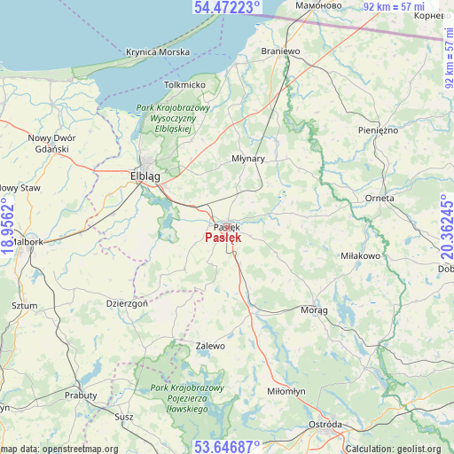
Pasłęk GPS coordinates[2]
54° 3' 41.76" North, 19° 39' 33.552" East
| Map corner | latitude | longitude |
|---|---|---|
| Upper-left | 54.47223°, | 18.9562° |
| Center: | 54.0616°, | 19.65932° |
| Lower-right: | 53.64687°, | 20.36245° |
| Map W x H: | 91.8×91.8 km | = 57×57mi |
| max Lat: | 54.83135° ⇑5.1% North |
| Pasłęk: | 54.0616° |
| min Lat: | ⇓94.9% South 49.21328° |
| min Long | Pasłęk | max Long |
| 14.20249° | 19.65932° | 24.03723° |
| W 52%⇐ | ⇒48% E |
Elevation
Elevation of Pasłęk is 39 m = 128 ft, and this is 152.4 m = 500 ft below average elevation for this country.
| Max E: |
974 m = 3196 ft | 95.2% |
| Avg. | 191.4 m = 628 ft | |
| Pasłęk | 39 m = 128 ft | |
Min E: |
-3 m = -10 ft | 4.8% |
See also: Poland elevation on elevation.city.
Geographical zone
Pasłęk is located in North temperate zone (between Tropic of Cancer and the Arctic Circle). Distance of this North polar circle is 1390.1 km =863.8 mi to North.| Distance of | km | miles | from Pasłęk |
|---|---|---|---|
| North Pole | 3996 | 2483 | to North |
| Arctic Circle | 1390.1 | 863.8 | to North |
| Tropic Cancer | 3405.2 | 2115.9 | to South |
| Equator | 6011.1 | 3735.1 | to South |


Nearby cities:
15 places around Pasłęk: (largest is in red/bold)
• Dzierzgoń
25.6 km =15.9 mi,  232°
232°
• Elbląg
19.2 km =11.9 mi,  301°
301°
• Gronowo Elbląskie
23.2 km =14.4 mi,  276°
276°
• Gronowo Górne
15.6 km =9.7 mi, 303°
• Kamiennik Wielki
15.6 km =9.7 mi,  331°
331°
• Markusy
17 km =10.6 mi,  265°
265°
• Małdyty
16.7 km =10.4 mi,  160°
160°
• Miłakowo
27.5 km =17.1 mi,  102°
102°
• Morąg
23.7 km =14.7 mi,  132°
132°
• Młynary
14.5 km =9 mi,  16°
16°
• Rychliki
12.1 km =7.5 mi, 225°
• Stare Pole
29.4 km =18.3 mi, 268°
• Suchacz
28.6 km =17.8 mi, 330°
• Tolkmicko
30 km =18.6 mi,  343°
343°
• Zalewo
24.3 km =15.1 mi,  188°
188°
Sources, notices
• [Note1] Compared only with cities in Poland existing in our database
• [Src1] Map data: © OpenStreetMap contributors (CC-BY-SA)
• [Src2] Other city data from geonames.org with taken over terms of usage.
• [Src3] Geographical zone / Annual Mean Temperature by Robert A. Rohde @ Wikipedia
