Dobromierz geodata
Dobromierz (Lower Silesia) is a populated place; located in Poland in Europe/Warsaw (GMT+2) time zone. With population of 800 people, there are 2851 cities with bigger population in this country. Compared to other cities in Poland, 57.3% of cities are located further ↑North; 91.2% of cities are located further →East and 82.8% of cities have lower elevation than Dobromierz. Note1


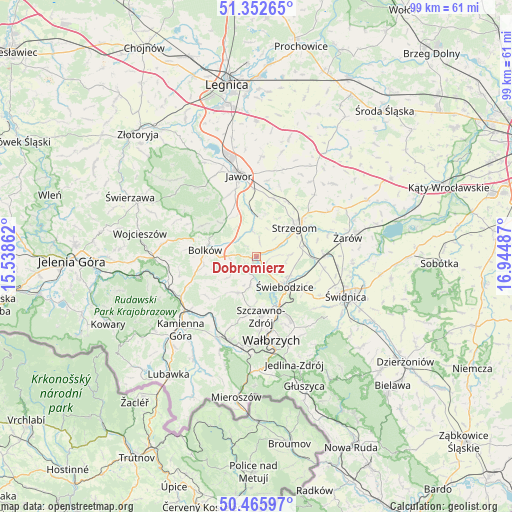
Dobromierz GPS coordinates[2]
50° 54' 41.112" North, 16° 14' 30.264" East
| Map corner | latitude | longitude |
|---|---|---|
| Upper-left | 51.35265°, | 15.53862° |
| Center: | 50.91142°, | 16.24174° |
| Lower-right: | 50.46597°, | 16.94487° |
| Map W x H: | 98.6×98.6 km | = 61.3×61.3mi |
| max Lat: | 54.83135° ⇑57.3% North |
| Dobromierz: | 50.91142° |
| min Lat: | ⇓42.7% South 49.21328° |
| min Long | Dobromierz | max Long |
| 14.20249° | 16.24174° | 24.03723° |
| W 8.8%⇐ | ⇒91.2% E |
Elevation
Elevation of Dobromierz is 279 m = 915 ft, and this is 87.6 m = 287 ft above average elevation for this country.
| Max E: |
974 m = 3196 ft | 17.2% |
| Dobromierz | 279 m 915 ft | |
| Avg. | 191.4 m = 628 ft | |
Min E: |
-3 m = -10 ft | 82.8% |
See also: Poland elevation on elevation.city.
Geographical zone
Dobromierz is located in North temperate zone (between Tropic of Cancer and the Arctic Circle). Distance of this North polar circle is 1740.4 km =1081.4 mi to North.| Distance of | km | miles | from Dobromierz |
|---|---|---|---|
| North Pole | 4346.2 | 2700.6 | to North |
| Arctic Circle | 1740.4 | 1081.4 | to North |
| Tropic Cancer | 3054.9 | 1898.2 | to South |
| Equator | 5660.8 | 3517.5 | to South |


Nearby cities:
15 places around Dobromierz: (largest is in red/bold)
• Boguszów-Gorce
17.6 km =10.9 mi,  188°
188°
• Bolków
9.9 km =6.2 mi,  276°
276°
• Czarny Bór
17.5 km =10.9 mi,  206°
206°
• Dziećmorowice
17.6 km =10.9 mi,  153°
153°
• Jawor
15.9 km =9.9 mi,  347°
347°
• Jaworzyna Śląska
13.4 km =8.3 mi,  89°
89°
• Marciszów
17.2 km =10.7 mi,  244°
244°
• Paszowice
12.7 km =7.9 mi,  330°
330°
• Stanowice
9.5 km =5.9 mi,  76°
76°
• Stare Bogaczowice
7.9 km =4.9 mi, 205°
• Strzegom
9.5 km =5.9 mi,  53°
53°
• Szczawno-Zdrój
12 km =7.5 mi,  175°
175°
• Wałbrzych
15.9 km =9.9 mi,  169°
169°
• Wierzchosławice
10.7 km =6.6 mi,  257°
257°
• Świebodzice
7.9 km =4.9 mi,  136°
136°
Sources, notices
• [Note1] Compared only with cities in Poland existing in our database
• [Src1] Map data: © OpenStreetMap contributors (CC-BY-SA)
• [Src2] Other city data from geonames.org with taken over terms of usage.
• [Src3] Geographical zone / Annual Mean Temperature by Robert A. Rohde @ Wikipedia
