Dłutów geodata
Dłutów (Łódź Voivodeship) is a seat of a third-order administrative division; located in Poland in Europe/Warsaw (GMT+2) time zone. With population of 1,000 people, there are 2459 cities with bigger population in this country. Compared to other cities in Poland, 57.3% of cities are located further ↓South; 52.9% of cities are located further →East and 64.1% of cities have lower elevation than Dłutów. Note1


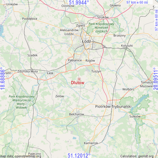
Dłutów GPS coordinates[2]
51° 33' 33.696" North, 19° 23' 31.128" East
| Map corner | latitude | longitude |
|---|---|---|
| Upper-left | 51.9944°, | 18.68886° |
| Center: | 51.55936°, | 19.39198° |
| Lower-right: | 51.12012°, | 20.09511° |
| Map W x H: | 97.2×97.2 km | = 60.4×60.4mi |
| max Lat: | 54.83135° ⇑42.7% North |
| Dłutów: | 51.55936° |
| min Lat: | ⇓57.3% South 49.21328° |
| min Long | Dłutów | max Long |
| 14.20249° | 19.39198° | 24.03723° |
| W 47.1%⇐ | ⇒52.9% E |
Elevation
Elevation of Dłutów is 212 m = 696 ft, and this is 20.6 m = 68 ft above average elevation for this country.
| Max E: |
974 m = 3196 ft | 35.9% |
| Dłutów | 212 m 696 ft | |
| Avg. | 191.4 m = 628 ft | |
Min E: |
-3 m = -10 ft | 64.1% |
See also: Poland elevation on elevation.city.
Geographical zone
Dłutów is located in North temperate zone (between Tropic of Cancer and the Arctic Circle). Distance of this North polar circle is 1668.3 km =1036.6 mi to North.| Distance of | km | miles | from Dłutów |
|---|---|---|---|
| North Pole | 4274.2 | 2655.9 | to North |
| Arctic Circle | 1668.3 | 1036.6 | to North |
| Tropic Cancer | 3126.9 | 1943 | to South |
| Equator | 5732.9 | 3562.3 | to South |


Nearby cities:
15 places around Dłutów: (largest is in red/bold)
• Bełchatów
21.3 km =13.2 mi,  186°
186°
• Brójce
21.2 km =13.2 mi,  56°
56°
• Buczek
17 km =10.6 mi,  248°
248°
• Czarnocin
20.3 km =12.6 mi,  79°
79°
• Dobroń
13.4 km =8.3 mi,  311°
311°
• Drużbice
10.6 km =6.6 mi,  179°
179°
• Grabica
13.1 km =8.1 mi,  132°
132°
• Ksawerów
13.8 km =8.6 mi,  3°
3°
• Pabianice
12 km =7.5 mi,  347°
347°
• Rzgów
13.5 km =8.4 mi,  30°
30°
• Starowa Góra
16 km =9.9 mi,  23°
23°
• Tuszyn
11.1 km =6.9 mi, 59°
• Wola Rakowa
19.7 km =12.2 mi,  50°
50°
• Zelów
15.9 km =9.9 mi,  228°
228°
• Łask
18.2 km =11.3 mi,  280°
280°
Sources, notices
• [Note1] Compared only with cities in Poland existing in our database
• [Src1] Map data: © OpenStreetMap contributors (CC-BY-SA)
• [Src2] Other city data from geonames.org with taken over terms of usage.
• [Src3] Geographical zone / Annual Mean Temperature by Robert A. Rohde @ Wikipedia
