Ksawerów geodata
Ksawerów (Łódź Voivodeship) is a seat of a third-order administrative division; located in Poland in Europe/Warsaw (GMT+2) time zone. With population of 6,269 people, there are 581 cities with bigger population in this country. Compared to other cities in Poland, 59.8% of cities are located further ↓South; 52.6% of cities are located further →East and 54.6% of cities have lower elevation than Ksawerów. Note1


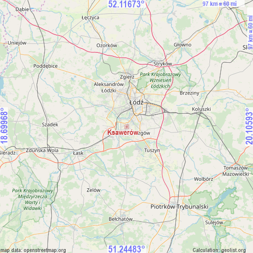
Ksawerów GPS coordinates[2]
51° 40' 58.368" North, 19° 24' 10.08" East
| Map corner | latitude | longitude |
|---|---|---|
| Upper-left | 52.11673°, | 18.69968° |
| Center: | 51.68288°, | 19.4028° |
| Lower-right: | 51.24483°, | 20.10593° |
| Map W x H: | 96.9×96.9 km | = 60.2×60.2mi |
| max Lat: | 54.83135° ⇑40.2% North |
| Ksawerów: | 51.68288° |
| min Lat: | ⇓59.8% South 49.21328° |
| min Long | Ksawerów | max Long |
| 14.20249° | 19.4028° | 24.03723° |
| W 47.4%⇐ | ⇒52.6% E |
Elevation
Elevation of Ksawerów is 184 m = 604 ft, and this is 7.4 m = 24 ft below average elevation for this country.
| Max E: |
974 m = 3196 ft | 45.4% |
| Avg. | 191.4 m = 628 ft | |
| Ksawerów | 184 m = 604 ft | |
Min E: |
-3 m = -10 ft | 54.6% |
See also: Poland elevation on elevation.city.
Geographical zone
Ksawerów is located in North temperate zone (between Tropic of Cancer and the Arctic Circle). Distance of this North polar circle is 1654.6 km =1028.1 mi to North.| Distance of | km | miles | from Ksawerów |
|---|---|---|---|
| North Pole | 4260.5 | 2647.4 | to North |
| Arctic Circle | 1654.6 | 1028.1 | to North |
| Tropic Cancer | 3140.7 | 1951.5 | to South |
| Equator | 5746.6 | 3570.8 | to South |


Nearby cities:
15 places around Ksawerów: (largest is in red/bold)
• Aleksandrów Łódzki
16.7 km =10.4 mi,  335°
335°
• Andrespol
17.2 km =10.7 mi,  73°
73°
• Brójce
17 km =10.6 mi,  96°
96°
• Dobroń
11.9 km =7.4 mi,  245°
245°
• Dłutów
13.8 km =8.6 mi,  183°
183°
• Kazimierz
16.5 km =10.3 mi,  305°
305°
• Konstantynów Łódzki
9 km =5.6 mi,  323°
323°
• Lutomiersk
15.4 km =9.6 mi,  300°
300°
• Pabianice
3.9 km =2.4 mi,  238°
238°
• Rzgów
6.5 km =4 mi,  109°
109°
• Starowa Góra
5.7 km =3.5 mi,  80°
80°
• Tuszyn
12 km =7.5 mi,  132°
132°
• Wodzierady
17.8 km =11.1 mi,  282°
282°
• Wola Rakowa
14.4 km =8.9 mi,  94°
94°
• Łódź
10.9 km =6.8 mi,  26°
26°
Sources, notices
• [Note1] Compared only with cities in Poland existing in our database
• [Src1] Map data: © OpenStreetMap contributors (CC-BY-SA)
• [Src2] Other city data from geonames.org with taken over terms of usage.
• [Src3] Geographical zone / Annual Mean Temperature by Robert A. Rohde @ Wikipedia
