Bełchatów geodata
Bełchatów (Łódź Voivodeship) is a seat of a second-order administrative division; located in Poland in Europe/Warsaw (GMT+2) time zone. With population of 62,896 people, there are 81 cities with bigger population in this country. Compared to other cities in Poland, 54.4% of cities are located further ↓South; 53.4% of cities are located further →East and 60.6% of cities have lower elevation than Bełchatów. Note1
Administrative division(s):
- Level 1: Łódź Voivodeship
- Level 2: Powiat bełchatowski
- Level 3: Bełchatów


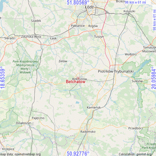
Bełchatów GPS coordinates[2]
51° 22' 7.788" North, 19° 21' 24.156" East
| Map corner | latitude | longitude |
|---|---|---|
| Upper-left | 51.80569°, | 18.65359° |
| Center: | 51.36883°, | 19.35671° |
| Lower-right: | 50.92776°, | 20.05984° |
| Map W x H: | 97.6×97.6 km | = 60.6×60.6mi |
| max Lat: | 54.83135° ⇑45.6% North |
| Bełchatów: | 51.36883° |
| min Lat: | ⇓54.4% South 49.21328° |
| min Long | Bełchatów | max Long |
| 14.20249° | 19.35671° | 24.03723° |
| W 46.6%⇐ | ⇒53.4% E |
Elevation
Elevation of Bełchatów is 202 m = 663 ft, and this is 10.6 m = 35 ft above average elevation for this country.
| Max E: |
974 m = 3196 ft | 39.4% |
| Bełchatów | 202 m 663 ft | |
| Avg. | 191.4 m = 628 ft | |
Min E: |
-3 m = -10 ft | 60.6% |
See also: Bełchatów elevation on elevation.city.
Geographical zone
Bełchatów is located in North temperate zone (between Tropic of Cancer and the Arctic Circle). Distance of this North polar circle is 1689.5 km =1049.8 mi to North.| Distance of | km | miles | from Bełchatów |
|---|---|---|---|
| North Pole | 4295.4 | 2669 | to North |
| Arctic Circle | 1689.5 | 1049.8 | to North |
| Tropic Cancer | 3105.8 | 1929.9 | to South |
| Equator | 5711.7 | 3549.1 | to South |


Nearby cities:
15 places around Bełchatów: (largest is in red/bold)
• Buczek
20 km =12.4 mi,  318°
318°
• Drużbice
10.9 km =6.8 mi,  13°
13°
• Dłutów
21.3 km =13.2 mi, 6°
• Gomunice
24.2 km =15 mi,  156°
156°
• Gorzkowice
23.8 km =14.8 mi,  135°
135°
• Grabica
17.3 km =10.7 mi,  44°
44°
• Kamieńsk
20.9 km =13 mi,  152°
152°
• Kleszczów
16.6 km =10.3 mi,  192°
192°
• Kluki
8.7 km =5.4 mi,  249°
249°
• Rozprza
21.4 km =13.3 mi,  110°
110°
• Sulmierzyce
23.3 km =14.5 mi,  208°
208°
• Szczerców
17.6 km =10.9 mi,  256°
256°
• Wola Krzysztoporska
15.8 km =9.8 mi,  99°
99°
• Zelów
14.3 km =8.9 mi, 318°
• Łękińsko
16.8 km =10.4 mi,  182°
182°
Sources, notices
• [Note1] Compared only with cities in Poland existing in our database
• [Src1] Map data: © OpenStreetMap contributors (CC-BY-SA)
• [Src2] Other city data from geonames.org with taken over terms of usage.
• [Src3] Geographical zone / Annual Mean Temperature by Robert A. Rohde @ Wikipedia
